PLAN of the Town of NEWBERN in Craven County NORTH CAROLINA
This map is also available in American Revolutionary Geographies Online (ARGO), a collections portal especially built for material relating to the American Revolutionary War Era. Visit ARGO to learn more about this item and explore the historical geography of North America in the late eighteenth century.
Item Information
- Title:
- PLAN of the Town of NEWBERN in Craven County NORTH CAROLINA
- Cartographer:
- Sauthier, Claude Joseph
- Former owner:
- George, III, King of Great Britain, 1738-1820
- Donor:
- George, IV, King of Great Britain, 1762-1830
- Name on Item:
-
Survey'd & Drawn in May 1769. By C,J, Sauthier.
- Date:
-
1769
- Format:
-
Maps/Atlases
Manuscripts
- Location:
- British Library
- Collection (local):
-
British Library Collection
- Subjects:
-
New Bern (N.C.)--Maps, Manuscript--Early works to 1800
- Places:
-
Craven (county)New Bern
- Extent:
- 1 map : manuscript pen and ink, colour ; 43 x 53 cm
- Terms of Use:
-
No known copyright restrictions.
This work is licensed for use under a Creative Commons Attribution Non-Commercial Share Alike License (CC BY-NC-SA).

- Scale:
-
Scale approximately 1:4,600
- Language:
-
English
- Catalog Record:
-
http://explore.bl.uk/BLVU1:LSCOP-ALL:BLL01004987629
- Notes:
-
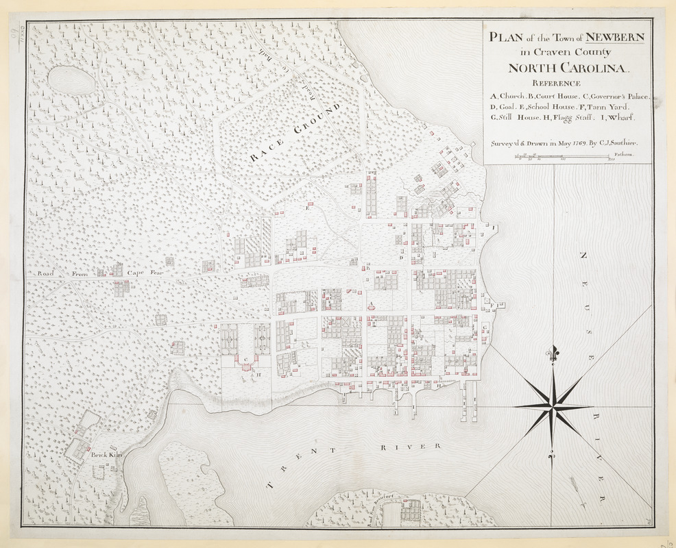
Relief shown by shading.
With a scale of fathoms within the title at upper right.
With a short lettered key (A-I) within the title at upper right identifying the "Church", "Court House", "Governor's Palace", "Goal", "School House", "Tann Yard", "Still House", "Flagg Staff" and "Wharf".
With a decorative compass arrow at lower right orienting north to the top of the map.
Shows roads.
Shows a "Race Ground".
Shows the Trent River and Neuse River.
Titled "A drawn Plan of the Town of Newbern in Craven County, North Carolina; surveyed and drawn in May 1769, by C.I. Sauthier" in the Catalogue of Maps, Prints, Drawings, etc., forming the geographical and topographical collection attached to the Library of his late Majesty King George the third, etc., London, 1829.
Titled 'A "plan of the town of Newbern, in Craven county, North Carolina; surveyed and drawn in May, 1769, by C.J. Sauthier;" drawn on a scale of 62 fathoms to an inch: 1 f. 8 in. x 1 f. 5 in.' in the Catalogue of the manuscript maps, charts, and plans, and of the topographical drawings in the British Museum.


