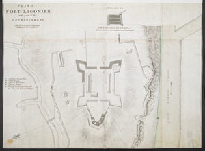
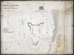
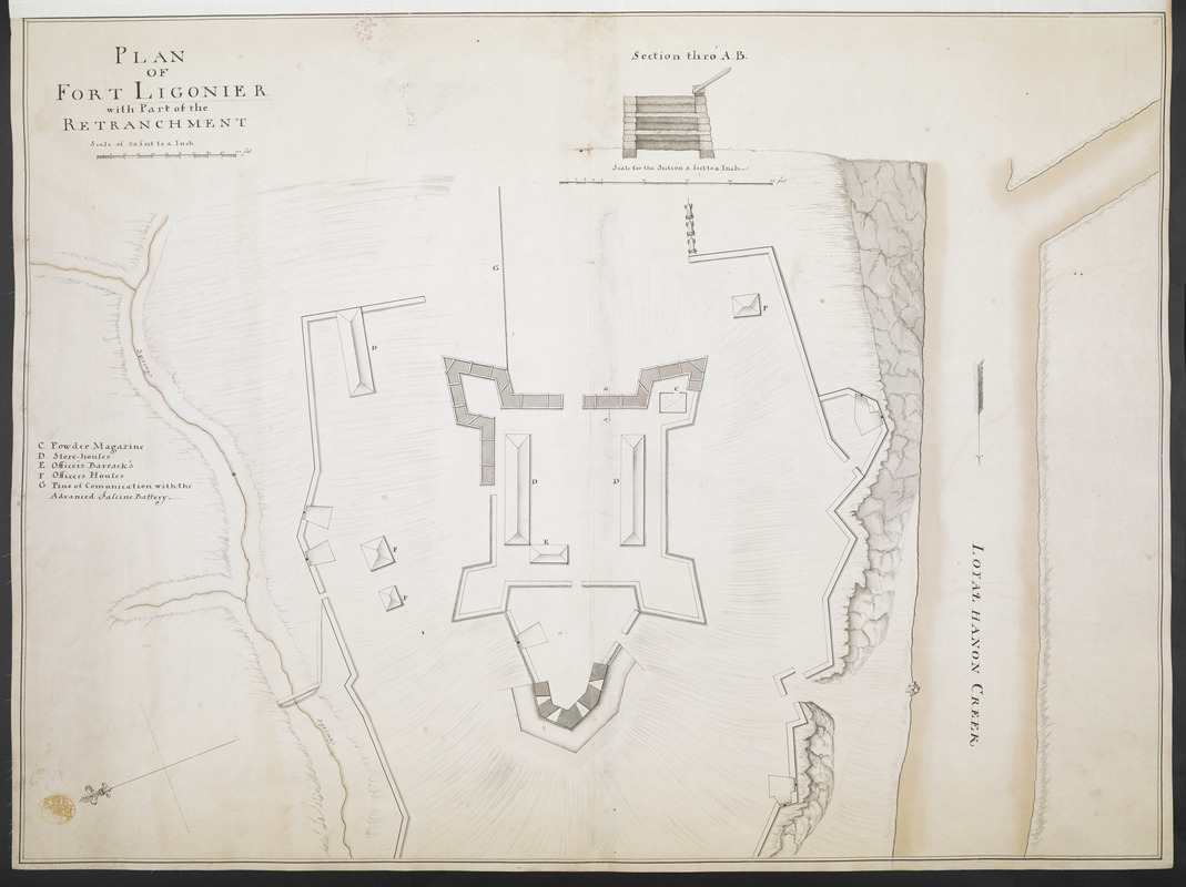
PLAN OF FORT LIGONIER with Part of the RETRANCHMENT
This map is also available in American Revolutionary Geographies Online (ARGO), a collections portal especially built for material relating to the American Revolutionary War Era. Visit ARGO to learn more about this item and explore the historical geography of North America in the late eighteenth century.
Item Information
- Title:
- PLAN OF FORT LIGONIER with Part of the RETRANCHMENT
- Former owner:
- George, III, King of Great Britain, 1738-1820
- Donor:
- George, IV, King of Great Britain, 1762-1830
- Date:
-
1758
- Format:
-
Maps/Atlases
Manuscripts
- Location:
- British Library
- Collection (local):
-
British Library Collection
- Subjects:
-
Military art and science--Pennsylvania--Fort Ligonier--Maps, Manuscript--Early works to 1800
Fort Ligonier (Pa.)--Maps, Manuscript--Early works to 1800
United States--History--French and Indian War, 1754-1763--Maps, Manuscript--Early works to 1800
- Places:
-
Westmoreland (county)Ligonier
- Extent:
- 1 map : manuscript pen and ink with watercolour ; 48 x 65 cm
- Terms of Use:
-
No known copyright restrictions.
This work is licensed for use under a Creative Commons Attribution Non-Commercial Share Alike License (CC BY-NC-SA).

- Scale:
-
Scale approximately 1:360
- Language:
-
English
- Catalog Record:
-
http://explore.bl.uk/BLVU1:LSCOP-ALL:BLL01004987655
- Notes:
-
Previous British Library cataloguing attributed a date of between 1750 and 1763. Fort Ligonier was built in 1758.
Relief shown pictorially and by shading.
With a "Scale of 30 feet to a Inch" below the title at upper left.
With a "Section thro' A.B." at upper right (also marked on the map) at a scale of five feet to one inch (1:60).
With a lettered key (C-G) at centre left identifying locations within the fort.
North is oriented to the left of the map and is indicated by a directional arrow at lower left.
Names "LOYAL HANSON CREEK".
Compare with Maps K.Top.122.15. - the map shows "the same" cartographic detail, at the same scale, by a different hand.
Titled "A drawn Plan of Fort Ligonier, with part of the Retrenchment" in the Catalogue of Maps, Prints, Drawings, etc., forming the geographical and topographical collection attached to the Library of his late Majesty King George the third, etc., London, 1829.
Titled 'A "plan of Fort Ligonier, with part of the retranchment;" drawn on a scale of 30 feet to an inch, with section on a scale of 5 feet to an inch: 2 f. 2 in. x 1 f. 7 in. (Two copies)' in the Catalogue of the manuscript maps, charts, and plans, and of the topographical drawings in the British Museum [the second copy referenced above is Maps K.Top.122.15.].