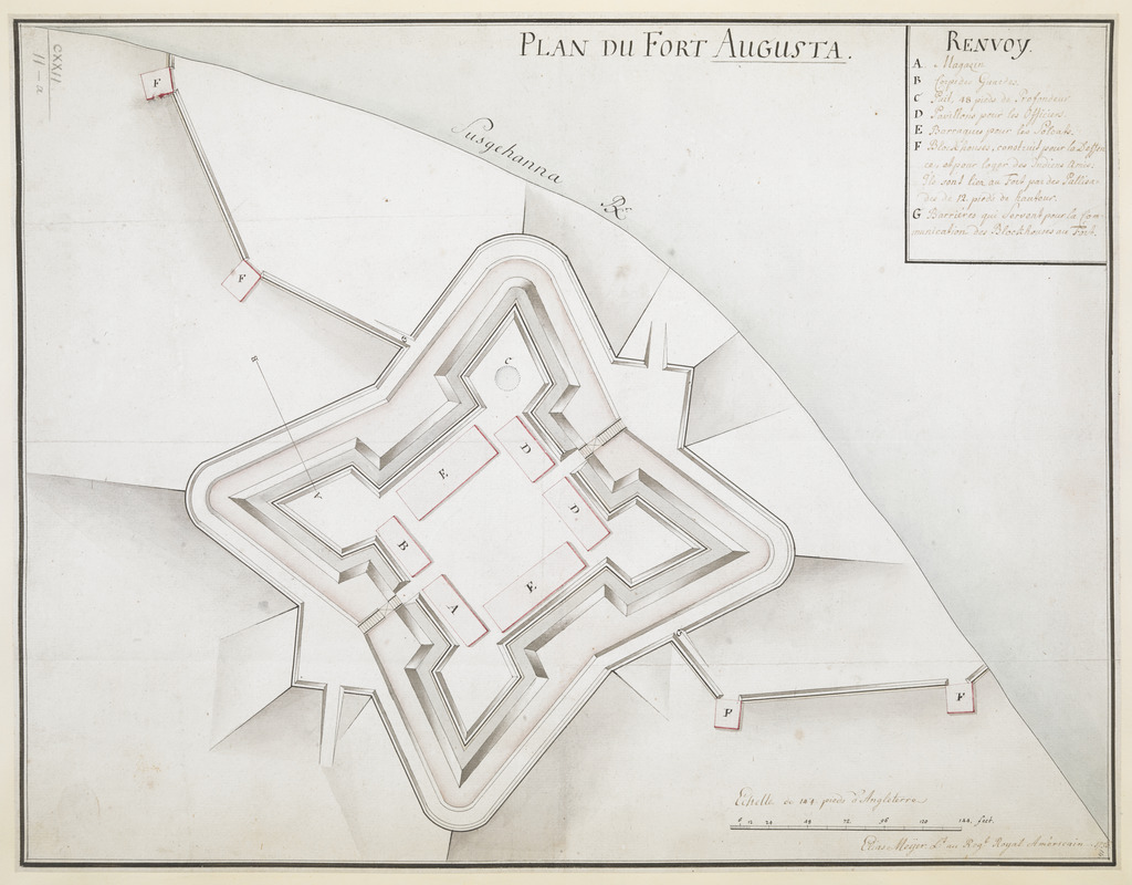
PLAN DU FORT AUGUSTA
This map is also available in American Revolutionary Geographies Online (ARGO), a collections portal especially built for material relating to the American Revolutionary War Era. Visit ARGO to learn more about this item and explore the historical geography of North America in the late eighteenth century.
Item Information
- Title:
- PLAN DU FORT AUGUSTA
- Cartographer:
- Meyer, Elias, -1766
- Former owner:
- George, III, King of Great Britain, 1738-1820
- Donor:
- George, IV, King of Great Britain, 1762-1830
- Name on Item:
-
Elias Meyer Reg.t au Royal Américain 1756.
- Date:
-
1756
- Format:
-
Maps/Atlases
Manuscripts
- Location:
- British Library
- Collection (local):
-
British Library Collection
- Subjects:
-
Military art and science--Pennsylvania--Shamokin--Maps, Manuscript--Early works to 1800
Fort Augusta (Pa.)--Maps, Manuscript--Early works to 1800
Shamokin (Pa.)--Maps--Early works to 1800
Sunbury (Pa.)--Maps, Manuscript--Early works to 1800
United States--History--French and Indian War, 1754-1763--Maps, Manuscript--Early works to 1800
- Places:
-
Northumberland (county)Shamokin
Northumberland (county)Sunbury
- Extent:
- 1 map : manuscript pen and ink with watercolour ; 35 x 45 cm
- Terms of Use:
-
No known copyright restrictions.
This work is licensed for use under a Creative Commons Attribution Non-Commercial Share Alike License (CC BY-NC-SA).

- Scale:
-
Scale approximately 1:460
- Language:
-
French
- Catalog Record:
-
http://explore.bl.uk/BLVU1:LSCOP-ALL:BLL01004987651
- Notes:
-
Echelle de 144 pieds d'Angleterre at lower right.
Short lettered key (A-G) identifying locations within the fort at upper right.
Profile line on map marked "A-B" relates to the "Profil coupé" at Maps K.Top.122.11.b.
Elias Meyer was sent to plan the strengthening of Fort Augusta - see “To Benjamin Franklin from William Clapham, 8 September 1756,” Founders Online, National Archives (http://founders.archives.gov/documents/Franklin/01-06-02-0231, ver. 2014-02-12). Source: The Papers of Benjamin Franklin, vol. 6, April 1, 1755, through September 30, 1756, ed. Leonard W. Labaree. New Haven and London: Yale University Press, 1963, pp. 501–502.
Meyer was responsible for other maps of forts in Pennsylvania in 1760 and 1761 - see reference MPHH 1/346 at The National Archives, Kew.
Titled "Plan et Profil dessinés du Fort Augusta; par le Lieut. E. Meyer, 1756" in the Catalogue of Maps, Prints, Drawings, etc., forming the geographical and topographical collection attached to the Library of his late Majesty King George the third, etc., London, 1829.
Titled 'A colored "plan du Fort Augusta;" drawn by Elias Meyer, lieut. in the Royal American regiment, 1756, on a scale of 62 feet to an inch: 1 f. 6 in. x 1 f. 1 in.' in the Catalogue of the manuscript maps, charts, and plans, and of the topographical drawings in the British Museum.
Fort Augusta in located in present-day Sunbury in Pennsylvania, an area previously known as Shamokin to Native Americans.

![[A colored map of the route between Albany and Oswego; drawn about 1756, on a scale of 2 miles to an inch]](https://bpldcassets.blob.core.windows.net/derivatives/images/commonwealth:hx11z3223/image_thumbnail_300.jpg)
![[A map of Fort Carillon and environs]](https://bpldcassets.blob.core.windows.net/derivatives/images/commonwealth:hx11z538d/image_thumbnail_300.jpg)
