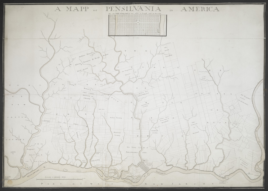
A MAPP OF PENSYLVANIA IN AMERICA
This map is also available in American Revolutionary Geographies Online (ARGO), a collections portal especially built for material relating to the American Revolutionary War Era. Visit ARGO to learn more about this item and explore the historical geography of North America in the late eighteenth century.
Item Information
- Title:
- A MAPP OF PENSYLVANIA IN AMERICA
- Former owner:
- George, III, King of Great Britain, 1738-1820
- Donor:
- George, IV, King of Great Britain, 1762-1830
- Date:
-
1756
- Format:
-
Maps/Atlases
Manuscripts
- Location:
- British Library
- Collection (local):
-
British Library Collection
- Subjects:
-
Pennsylvania--Maps--Early works to 1800
Philadelphia (Pa.)--Maps--Early works to 1800
- Places:
-
Philadelphia (county)Philadelphia
- Extent:
- 1 map on 2 sheets : joined and laid on linen, manuscript pen and ink with watercolour ; 75 x 106 cm
- Terms of Use:
-
No known copyright restrictions.
This work is licensed for use under a Creative Commons Attribution Non-Commercial Share Alike License (CC BY-NC-SA).

- Scale:
-
Scale approximately 1:84,000
- Language:
-
English
- Catalog Record:
-
http://explore.bl.uk/BLVU1:LSCOP-ALL:BLL01004987640
- Notes:
-
Date from British Museum manuscripts catalogue.
With a "SCALE OF ENGLISH MILES" at lower left.
Title at upper centre.
Inset map of Philadelphia beneath title "The city of PHILADELPHIA two miles in length and in Breadth" (scale not given).
Names land proprietors.
A copy of J.F.W. Des Barres untitled map in the "Atlantic Neptune" of 1777 that was a reproduced, updated and republished copy of Thomas Holmes' seventeenth-century map of Pennsylvania? - Snyder (see Maps K.Top.122.3. for an example of the Holmes map in a later state).
Titled "A drawn Map of Pensilvania, with a Plan of Philadelphia" in the Catalogue of Maps, Prints, Drawings, etc., forming the geographical and topographical collection attached to the Library of his late Majesty King George the third, etc., London, 1829.
Titled 'A "Mapp of Pensilvania;" drawn about 1756, on a scale of 1 1/3 mile to an inch, with a plan of Philadelphia on a larger scale: 3 f. 5 in. x 1 f. 5 in.' in the Catalogue of the manuscript, maps, charts, and plans, and of the topographical drawings in the British Museum.
Geographical detail extends along the Delaware River from Newcastle to the "Mannor of HiGHLANDS", in present-day Pennsylvania.

![[Environs of Philadelphia]](https://bpldcassets.blob.core.windows.net/derivatives/images/commonwealth:7h149x76d/image_thumbnail_300.jpg)


