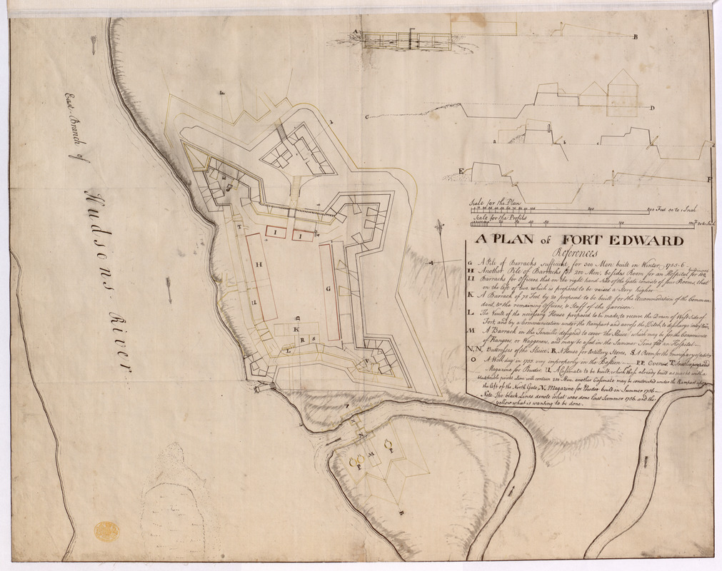
A PLAN of FORT EDWARD
This map is also available in American Revolutionary Geographies Online (ARGO), a collections portal especially built for material relating to the American Revolutionary War Era. Visit ARGO to learn more about this item and explore the historical geography of North America in the late eighteenth century.
Item Information
- Title:
- A PLAN of FORT EDWARD
- Former owner:
- George, III, King of Great Britain, 1738-1820
- Donor:
- George, IV, King of Great Britain, 1762-1830
- Contributor:
- Rogers’ Rangers
- Date:
-
1757
- Format:
-
Maps/Atlases
Manuscripts
- Location:
- British Library
- Collection (local):
-
British Library Collection
- Subjects:
-
Fortification--New York (State)--Fort Edward--Maps, Manuscript--Early works to 1800
Military art and science--New York (State)--Fort Edward--Maps, Manuscript--Early works to 1800
Fort Edward (N.Y.)--Maps, Manuscript--Early works to 1800
United States--History--French and Indian War, 1754-1763--Maps, Manuscript--Early works to 1800
- Places:
-
Washington (county)Fort Edward
- Extent:
- 1 map : manuscript pen and ink with watercolour ; 47 x 61 cm
- Terms of Use:
-
No known copyright restrictions.
This work is licensed for use under a Creative Commons Attribution Non-Commercial Share Alike License (CC BY-NC-SA).

- Scale:
-
Scale approximately 1:600
- Language:
-
English
- Catalog Record:
-
http://explore.bl.uk/BLVU1:LSCOP-ALL:BLL01004987748
- Notes:
-
A date of about 1757 is attributed to the map as the key includes references to "last Summer 1756".
Relief is shown by shading.
With four inset profiles at upper left detailing profiles through the fort at a scale of 20 feet to an inch (1:240).
With a list of references (G to V) beneath the title detailing the existing and proposed works.
The references include mention of the "rangers" - Rogers' Rangers.
Colour on the map is used to highlight the existing (red) and proposed (yellow) works.
Titled "A drawn Plan of Fort Edward" in the Catalogue of Maps, Prints, Drawings, etc., forming the geographical and topographical collection attached to the Library of his late Majesty King George the third, etc., London, 1829.
Titled 'A colored "plan of Fort Edward," shewing what was built up to the summer of 1756, and what remained to be done; drawn on a scale of 50 feet to an inch; with profils on a scale of 20 feet to an inch 2 f. x 1 f. 6 in.' in the Catalogue of the manuscript maps, charts, and plans, and of the topographical drawings in the British Museum.