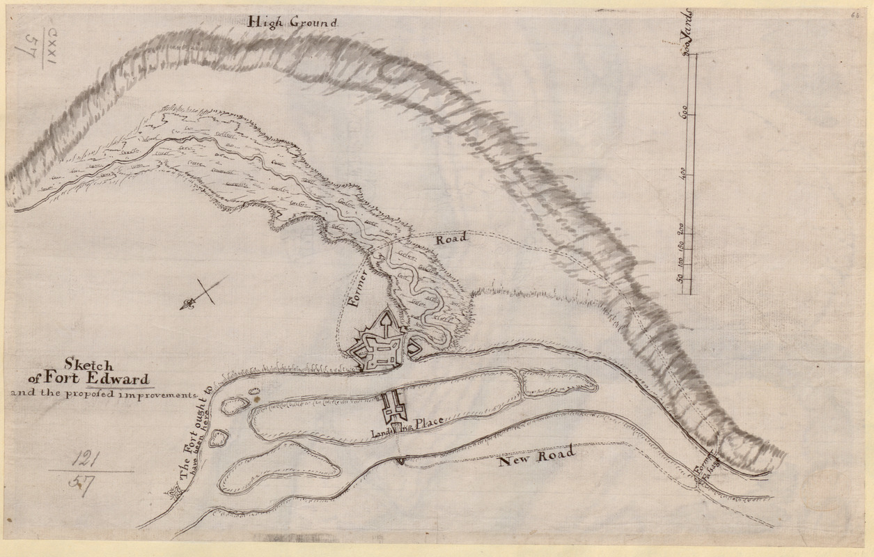
Sketch of Fort Edward and the proposed improvements
This map is also available in American Revolutionary Geographies Online (ARGO), a collections portal especially built for material relating to the American Revolutionary War Era. Visit ARGO to learn more about this item and explore the historical geography of North America in the late eighteenth century.
Item Information
- Title:
- Sketch of Fort Edward and the proposed improvements
- Former owner:
- George, III, King of Great Britain, 1738-1820
- Donor:
- George, IV, King of Great Britain, 1762-1830
- Date:
-
1757–1759
- Format:
-
Maps/Atlases
Manuscripts
- Location:
- British Library
- Collection (local):
-
British Library Collection
- Subjects:
-
Fortification--New York (State)--Fort Edward--Maps, Manuscript--Early works to 1800
Military art and science--New York (State)--Fort Edward--Maps, Manuscript--Early works to 1800
Fort Edward (N.Y.)--Maps, Manuscript--Early works to 1800
United States--History--French and Indian War, 1754-1763--Maps, Manuscript--Early works to 1800
- Places:
-
Washington (county)Fort Edward
- Extent:
- 1 map : manuscript pen and ink with grayscale watercolour ; 23 x 36 cm
- Terms of Use:
-
No known copyright restrictions.
This work is licensed for use under a Creative Commons Attribution Non-Commercial Share Alike License (CC BY-NC-SA).

- Scale:
-
Scale approximately 1:7,200
- Language:
-
English
- Catalog Record:
-
http://explore.bl.uk/BLVU1:LSCOP-ALL:BLL01004987746
- Notes:
-
Previous British Library cataloguing has dated the map about 1758. Improvements to Fort Edward were carried out between 1756 and 1759, and construction on Rogers Island (shown on this map) took place in 1757 and 1758 - http://www.rogersisland.org/programs/HISTORY%20OF%20FORT%20EDWARD%20AND%20ROGERS%20ISLAND.pdf
With a scale at upper right where 200 yards are equal to one inch.
A compass arrow orients north to the left of the map.
Shows fortifications on Rogers Island.
A note on the map reads "The Fort ought to have been positioned here" - located on the east bank, north of Rogers Island.
Titled "A drawn sketch of Fort Edward and the proposed improvements" in the Catalogue of Maps, Prints, Drawings, etc., forming the geographical and topographical collection attached to the Library of his late Majesty King George the third, etc., London, 1829.
Titled 'A "sketch of Fort Edward and the proposed improvements;" drawn about 1758, on a scale of 200 yards to an inch: 1 f. 2 in. x 9 in.' in the Catalogue of the manuscript maps, charts, and plans, and of the topographical drawings in the British Museum.