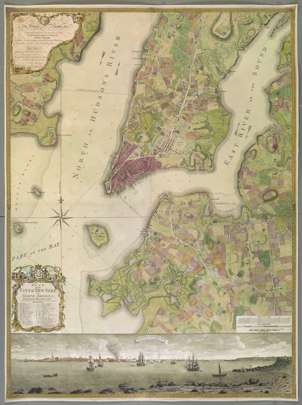
PLAN of the CITY of NEW YORK, in North America : Surveyed in the Years 1766 & 1767
This map is also available in American Revolutionary Geographies Online (ARGO), a collections portal especially built for material relating to the American Revolutionary War Era. Visit ARGO to learn more about this item and explore the historical geography of North America in the late eighteenth century.
Item Information
- Title:
- PLAN of the CITY of NEW YORK, in North America : Surveyed in the Years 1766 & 1767
- Cartographer:
- Ratzer, Bernard
- Former owner:
- George, III, King of Great Britain, 1738-1820
- Donor:
- George, IV, King of Great Britain, 1762-1830
- Engraver:
- Kitchin, Thomas, 1718-1784
- Dedicatee:
- Moore, Henry, Sir, 1713-1769
- Name on Item:
-
B. Ratzer, Lieut.t in His Majestys 60th or Royal American Reg.t.
- Date:
-
1770
- Format:
-
Maps/Atlases
- Location:
- British Library
- Collection (local):
-
British Library Collection
- Subjects:
-
New York (N.Y.)--Maps--Early works to 1800
Manhattan (New York, N.Y.)--Maps--Early works to 1800
- Places:
-
New YorkManhattan
- Extent:
- 1 map on 3 sheets : joined and laid on linen, copperplate engraving with original hand colour ; map 118 x 86 cm
- Terms of Use:
-
No known copyright restrictions.
This work is licensed for use under a Creative Commons Attribution Non-Commercial Share Alike License (CC BY-NC-SA).

- Publisher:
-
[London] :
[Thomas Kitchin]
- Scale:
-
Scale approximately 1:1,000
- Language:
-
English
- Catalog Record:
-
http://explore.bl.uk/BLVU1:LSCOP-ALL:BLL01016739223
- Notes:
-
Relief is shown by shading.
Shows sounding depths.
With a scale on the lower sheet showing a "Scale of 5000 Feet", a "Scale of One Mile" and a "Scale of Yards".
The title appears in a decorative surround at lower left with a list of references (a-z and 1-10).
An inset view "A South West View of the City of New York, Taken from the Governours Island at *"is shown across the bottom of the map. The source for the view was a watercolour by Captain-Lieutenant Thomas Davies, dated 1760 - Cohen and Augustyn.
A large dedication appears at upper left; "To His Excellency Sir Henry Moore, Bar:t Captain General and Governour in Chief, In and Over His Majesty's Province of NEW YORK and the Territories depending thereon in America Chancellor and Vice admiral of the same. This Plan of the City of New York and its Environs, survey'd and Laid down: Is most Humbly Dedicated by His Excellency's Most Obed.t Humble Servant, B. Ratzer Lieut.t in his Majesty's 60th or Royal American Reg.t".
The dedication includes the imprint "Thos. Kitchin Sculpt. Engraver to His Late Royal Highness the Duke of York, &c".
The first state of the map (undated but about 1770). The second (1776) state (for an example see Maps K.Top.121.36.a.) has the imprint of Faden and Jefferys - Cohen and Augustyn.
The attribution of 1770 for the first state of the map is based on a "New-York Gazette" advertisement for the map in October 1770 - Pritchard & Taliaferro.
Deàk (and then Pritchard & Taliferro and Cohen & Augustyn, both based on Deàk) lists only two known examples of the map in the first state (this copy and another at the New York Historical Society). However, Cumming identifies an example at Alnwick Castle and another at the New York State Library in Albany - however, the New York State Library example is a later copy by Robert Cochrane Bacot published by Murphy and Bechtel in 1873 [Call number (7471) 1766-67 202-2442]. Another example has since been discovered at the Brooklyn Historical Society (reference in the New York Times article by Michael Wilson, published January 16, 2011 - Cunning, Care and Sheer Luck Save Rare Map), making four known examples of this first state in total.
Titled "Another Copy of ditto. A Roll" where ditto was "A Plan of the City of New York and its Environs, surveyed and laid down by Lieut. B. Ratzer, 1766, 7, with a View of ditto; published by Jefferys and Faden, 1776. Two sheets" in the Catalogue of Maps, Prints, Drawings, etc., forming the geographical and topographical collection attached to the Library of his late Majesty King George the third, etc., London, 1829.
Previously titled "Plan of the City of New York, in North America: surveyed in the years 1766 & 1767. To His Excellency Sir Henry Moore, Bart ... This Plan of the City of New York and its environs, survey'd and laid down. Is ... dedicated, by ... B. Ratzer ... Thos. Kitchin sculpt., etc. Scale of one mile[ = 16 2/5 mm.]. A South West View of the City of New York, taken from the Government Island" in British Library cataloguing.
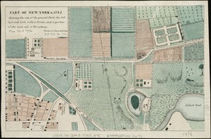
Extends northwards to approximately present-day Fiftieth Street.
Copy at Maps K.Top.121.36.b. Exhibited: "The American War of Independence, 1775-84: a commemorative exhibition organized by the Map Library and the Department of Manuscripts of the British Library Reference Division", The British Library, London, 4 July 1975 – 11 November 1975. Uk