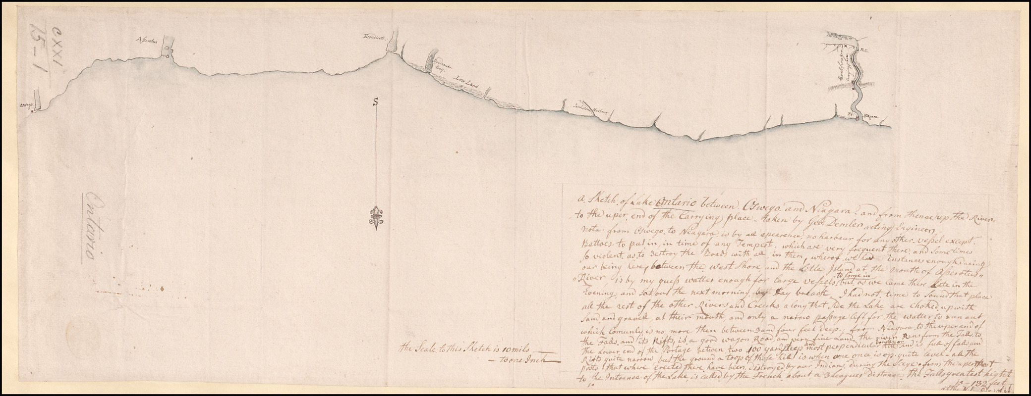
A Sketch of Lake Ontario between Oswego and Niagara and from thence up the River to the upper end of the Carrying place
This map is also available in American Revolutionary Geographies Online (ARGO), a collections portal especially built for material relating to the American Revolutionary War Era. Visit ARGO to learn more about this item and explore the historical geography of North America in the late eighteenth century.
Item Information
- Title:
- A Sketch of Lake Ontario between Oswego and Niagara and from thence up the River to the upper end of the Carrying place
- Cartographer:
- Demler, George
- Former owner:
- George, III, King of Great Britain, 1738-1820
- Donor:
- George, IV, King of Great Britain, 1762-1830
- Name on Item:
-
taken by Geo: Demler acting Engineer.
- Date:
-
1759–1764
- Format:
-
Maps/Atlases
Manuscripts
- Location:
- British Library
- Collection (local):
-
British Library Collection
- Subjects:
-
Ontario, Lake (N.Y. and Ont.)--Maps, Manuscript--Early works to 1800
United States--History--French and Indian War, 1754-1763--Maps, Manuscript--Early works to 1800
- Places:
-
Ontario, Lake
- Extent:
- 1 map : manuscript pen and ink with watercolour ; 19 x 50 cm
- Terms of Use:
-
No known copyright restrictions.
This work is licensed for use under a Creative Commons Attribution Non-Commercial Share Alike License (CC BY-NC-SA).

- Scale:
-
Scale approximately 1:633,600
- Language:
-
English
- Catalog Record:
-
http://explore.bl.uk/BLVU1:LSCOP-ALL:BLL01004987719
- Notes:
-
The reference to a siege on the map (the Battle of Fort Niagara in July 1759) dates this map to no earlier than 1759. Other maps by George Demler of this region are dated before 1764 - see British Library, MS 57708.
Oriented with north to the bottom of the map.
A manuscript note after the map's title is as follows; "Nota: from Oswego to Niagara is by all appearence no harbour for any other vessel except Battoes to put in in times of any Tempest, which are very frequent there, and sometimes so violent as to destroy the Boats with all in them, whereof we had instances enough during our being here; between the West Shore and the Little Island at the mouth of Asserotus River is by my guess watter enough for large Vessels to come in but as we came there late in the Evening, and let out the next morning, by day break, I had not time to sound that place all the rest of the other Rivers and Creeks a long that side the Lake are choked up with sand and gravel, at their mouth, and only a narrow passage left for the watter to run out which comunly is no more than between 3 and four feet deep. from Niagara to to the upper end of the Falls, and its Rifts, is a good Wagon Road and very fine Land. the river Runs from the falls to the Lower end of the Portage between, two 100 yard steep and most perpendicular bonds or Hills and is full of falls and Rifts quite narrow, but the ground a toop of those hills is when one once is up, quite level. all the posts that where erected there have been distroyed by our Indians during the Siege. from the upper to the Intrance of the Lake is called by the French about a 3 Leagues distance. the Falls greatest hight is 132 feet at the N. End of it".
The "Scale of this Sketch is 10 miles to one inch".
Lieutenant George Demler was responsible for a further map of Fort Niagara in 1764 (British Library, MS 57708).
The Bibliothèque et Archives Canada hold a photocopy of this map (CARTO30962), also dated to 1759, taken from this British Library copy (Maps K.Top.121.15.1.).
The William L. Clements Library list "A sketch of the south shore; of Lake Ontario between Oswego; and niagara, and from thence up the river to a-boute two miles above the Falls. done by Geo[rge] Demler engineer". This map is also at a scale of 1 inch to 10 miles. The William L. Clements Library attribute a date of about 1753. The map may be found in the Gage Papers and is listed in Brun, Christian. Guide to the manuscript maps in the William L. Clements Library.
Titled "A drawn Sketch of Lake Ontario, between Oswego and Niagara, by G. Demler, Eng.r" in Catalogue of Maps, Prints, Drawings, etc., forming the geographical and topographical collection attached to the Library of his late Majesty King George the third, etc., London, 1829.
Titled 'A colored chart of the south coast of "Lake Ontario, between Oswego and Niagara, and from thence up the river to the upper end of the carrying place: taken by George Demler, acting engineer;" drawn on a scale of 10 miles to an inch: 1 f. 8 in. x 1 f. 4 in." in the Catalogue of the manuscript maps, charts, and plans, and of the topographical drawings in the British Museum.


![[Lake Ontario]](https://bpldcassets.blob.core.windows.net/derivatives/images/commonwealth:hx11xz576/image_thumbnail_300.jpg)
