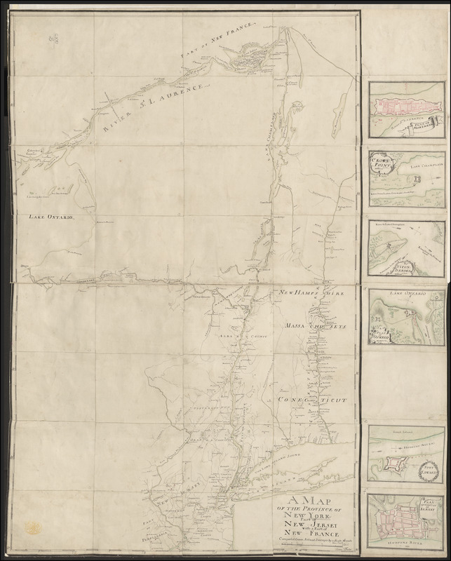
A MAP OF THE PROVINCE OF NEW-YORK, PART OF NEW JERSEY with a Part of NEW FRANCE Composed from Actual Surveys
This map is also available in American Revolutionary Geographies Online (ARGO), a collections portal especially built for material relating to the American Revolutionary War Era. Visit ARGO to learn more about this item and explore the historical geography of North America in the late eighteenth century.
Item Information
- Title:
- A MAP OF THE PROVINCE OF NEW-YORK, PART OF NEW JERSEY with a Part of NEW FRANCE Composed from Actual Surveys
- Cartographer:
- Pfister, Francis, 1740-1777
- Former owner:
- George, III, King of Great Britain, 1738-1820
- Donor:
- George, IV, King of Great Britain, 1762-1830
- Surveyor:
- Christie, Gabriel, 1722-1799
- Name on Item:
-
by Franc:is Pfister.
- Date:
-
1759
- Format:
-
Maps/Atlases
Manuscripts
- Location:
- British Library
- Collection (local):
-
British Library Collection
- Subjects:
-
Fortification--New York (State)--Maps, Manuscript--Early works to 1800
New York (State)--Maps, Manuscript--Early works to 1800
New England--Maps, Manuscript--Early works to 1800
United States--History--French and Indian War, 1754-1763--Maps, Manuscript--Early works to 1800
Montréal (Québec)--Maps, Manuscript--Early works to 1800
Crown Point (N.Y.)--Maps, Manuscript--Early works to 1800
Fort Ticonderoga (N.Y.)--Maps, Manuscript--Early works to 1800
Fort Oswego (Oswego, N.Y.)--Maps, Manuscript--Early works to 1800
Fort Edward (N.Y.)--Maps, Manuscript--Early works to 1800
Albany (N.Y.)--Maps, Manuscript--Early works to 1800
- Places:
-
Oswego (county)Fort Oswego
Washington (county)Fort Edward
New England (area)
Albany (county)Albany
CanadaMontreal
Essex (county)Fort Ticonderoga (transport point)
Essex (county)Crown Point (cape)
- Extent:
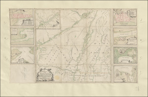
- 7 maps on 1 sheet: dissected into 40 pieces (including town plans) and laid on linen, manuscript pen and ink with watercolour ; map 65 x 41 cm, sheet 66 x 53 cm
- Terms of Use:
-
No known copyright restrictions.
This work is licensed for use under a Creative Commons Attribution Non-Commercial Share Alike License (CC BY-NC-SA).

- Scale:
-
Scale approximately 1:1,013,760
- Language:
-
English
- Catalog Record:
-
http://explore.bl.uk/BLVU1:LSCOP-ALL:BLL01016738049
- Notes:
-
Relief is shown pictorially.
Shows a scale of 16 miles to one inch.
Six plans of forts and towns within the region depicted [each previously catalogued separately by the British Library, now listed here] are inset to the right of the central map
Includes a "PLAN OF MONTREAL". Previously titled "A colored plan of Montreal; drawn about 1760, by Francis Pfister" in the Catalogue of the manuscript maps, charts, and plans, and of the topographical drawings in the British Museum.
Includes a map of "CROWN POINT" (with a scale of 1000 feet to 6/16 inch, or 1:32,000). Previously titled "A colored plan of Crown Point on Lake Champlain; drawn by Francis Pfister, about 1760, on a scale of 2 inches to a mile" in the Catalogue of the manuscript maps, charts, and plans, and of the topographical drawings in the British Museum.
Includes a map of "TICONDEROGA" (with a scale of 100 yards to 6/16 inch or 1:9600). Previously titled "A colored plan of Ticonderoga; drawn by Francis Pfister, about 1760, on a scale of 230 yards to an inch" in the Catalogue of the manuscript maps, charts, and plans, and of the topographical drawings in the British Museum.
Includes a map of "FORT EDWARD". Previously titled "A colored plan of Fort Edward,; drawn about 1760, by Francis Pfister" in the Catalogue of the manuscript maps, charts, and plans, and of the topographical drawings in the British Museum.
Includes a map of "PLAN OF THE CITY OF ALBANY". Previously titled "A colored plan of the city of Albany, on Hudson's River; drawn about 1760, by Francis Pfister" in the Catalogue of the manuscript maps, charts, and plans, and of the topographical drawings in the British Museum.
Includes a "PLAN OF OSWEGO" (with a scale of 300 yards to 1/4 inch or 1:43,200). Previously titled "A colored plan of Oswego, on lake Ontario; drawn by Francis Pfister, about 1760, on a scale of 300 yards to an inch" in the Catalogue of the manuscript maps, charts, and plans, and of the topographical drawings in the British Museum.
Similar plans of towns and forts also appear on the map of the "... SCENE OF ACTION ..." in New York - see Maps K.Top.121.9.1.
The map's title appears in a simple surround at lower right.
Shows roads.
Shows forts.
Bordered by graticule lines giving latitude and longitude.
Compare a similar example of the map on one sheet, lacking the plans of forts in the King's Topographical Collection at Maps K.Top.121.1. which has a manuscript note in pencil added beneath the title cartouche; "done from actual Surveys by Major Christie 1759 (Catalogue)".
Compare Pfister's map at a larger size - see Add Ms 57,713.1.
From David Y. Allen's article "Comparing Eighteenth-Century Maps of New York State Using Digital Imagery" on the New York Map Society website at http://www.newyorkmapsociety.org/FEATURES/ALLEN.HTM#note21 ; "Captain (later Major) Christie is mentioned almost in passing in the journals of James Montresor, as is Francis Pfister. Both belonged to the Royal American Regiment, along with the two Montresors. See G.D. Scull, [Editor], The Montresor Journals, Collections of the New-York Historical Society, XIV (New York: New-York Historical Society, 1881), 53, 89, 90, 94. Nothing is said in Montresor's journals about Christie's activities as a surveyor, and there is even some uncertainty about his identity. Tooley's Dictionary of Mapmakers identifies him as “Charles Christie,” but gives no references ... Most probably, he is Gabriel Christie, who later became a major general and an important estate owner in Canada. Information about Gabriel Christie's life can be found in The Dictionary of Canadian Biography, and at http://www.nysm.nysed.gov/albany/bios/c/gachristie.html. But these sources say nothing directly about his activities (if any) as military surveyor."
Compare a copy of the map held at The National Archives in Kew (CO 700/NewYork24) titled "A Map of the Province of New York, part of New England with a part of New France ... from Actual Surveys ... by Francis Pfister, Ensign in the 1st Battalion, Royal American Regt, 1759. MS. 1 inch to 16 miles".
Titled "A drawn Map of the Province of New York, part of New Jersey, with a part of New France: by F. Pfister" in the Catalogue of Maps, Prints, Drawings, etc., forming the geographical and topographical collection attached to the Library of his late Majesty King George the third, etc., London, 1829.
Titled "Another copy of the preceding survey, drawn on the same scale: 2 f. 2 in. x 1 f. 7 in., with small plans of the forts" where the preceding was 'A "map of the province of New York and part of New England, with a part of New France, the whole composed from actual surveys by Major Christie," in 1759; drawn by Francis Pfister, on a scale of 16 miles to an inch: 2 f. 2 in. x 1 f. 5 in.' in the Catalogue of the manuscript maps, charts, and plans, and of the topographical drawings in the British Museum.
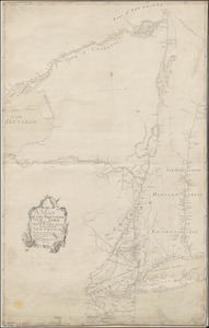
The map shows parts of the present-day states of Pensylvania, New Jersey, New York, Connecticut, Massachusetts, Rhode Island and Vermont, and includes parts of Ontario. The geographic details has a focus along the courses of the rivers Hudson, Connecticut, Mohawk, Richelieu, Owsego, parts of the St Lawrence, and many tributaries. Detail extends from Montreal in the north to Burlington in the south, and from Long Island in the east to Oswego on Lake Ontario in the west.


![[A colored map of the route between Albany and Oswego; drawn about 1756, on a scale of 2 miles to an inch]](https://bpldcassets.blob.core.windows.net/derivatives/images/commonwealth:hx11z3223/image_thumbnail_300.jpg)
