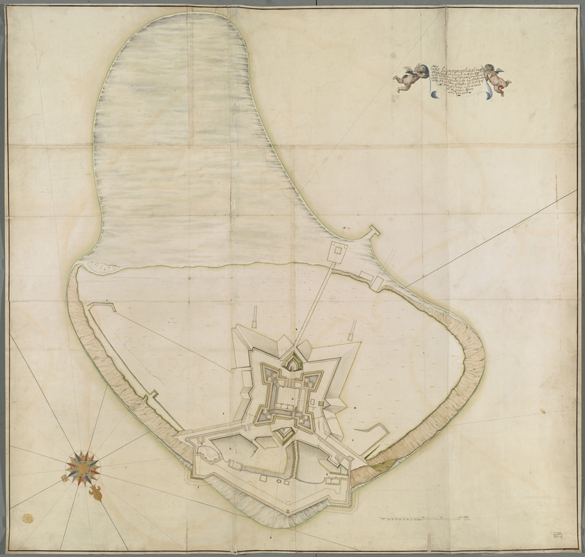
The Icqnographical draft of Castle Island where upon is built Her Maj.ties Castle and by Her Maj.ties Special Command named Castle William cituated in the bay of Boston three Miles S:E of ye town of Boston and South 3/4 of a Mile of ye Mean
Item Information
- Title:
- The Icqnographical draft of Castle Island where upon is built Her Maj.ties Castle and by Her Maj.ties Special Command named Castle William cituated in the bay of Boston three Miles S:E of ye town of Boston and South 3/4 of a Mile of ye Mean
- Cartographer:
- Romer, Wolfgang William, 1640-1713
- Former owner:
- George, III, King of Great Britain, 1738-1820
- Donor:
- George, IV, King of Great Britain, 1762-1830
- Name on Item:
-
made & Surva:ied By Collonel Römer in ye Yare 1705.
- Date:
-
1705
- Format:
-
Maps/Atlases
Manuscripts
- Location:
- British Library
- Collection (local):
-
British Library Collection
- Subjects:
-
Islands--Massachusetts--Castle Island--Maps, Manuscript--Early works to 1800
Fortification--Massachusetts--Castle Island--Maps, Manuscript--Early works to 1800
Castle Island (Mass.)--Maps, Manuscript--Early works to 1800
Castle Island (Mass.)--Defenses--Early works to 1800
- Places:
-
MassachusettsSuffolk (county)Castle Island (cape)
- Extent:
- 1 map on 4 sheets : joined and laid on linen, manuscript pen and ink with watercolour ; 97 x 102 cm
- Terms of Use:
-
No known copyright restrictions.
This work is licensed for use under a Creative Commons Attribution Non-Commercial Share Alike License (CC BY-NC-SA).

- Scale:
-
Scale approximately 1:370
- Language:
-
English
- Catalog Record:
-
http://explore.bl.uk/BLVU1:LSCOP-ALL:BLL01004987803
- Notes:
-
Relief is shown by shading.
Accompanied by profiles on separate sheets (see Maps K.Top.120.39.b.) - these are identified by lettered pairs (A-B, C-D etc) on this map.
A scale of 200 feet is given at lower right where 50 feet is equal to 1 5/8 inch.
A decorative compass rose with gold highlighting is given at lower left, and orients north to the bottom of the map.
Wolfgang William Romer was responsible for building Castle William (now Fort Independence) on Castle Island which mounted 100 guns - DNB.
The title appears in a scroll at upper right supported by cherubim.
Titled "a drawn plan of Castle Island in Boston Bay by Col. Romer, 1705. Four sheets: with Profiles of ditto" in the Catalogue of Maps, Prints, Drawings, etc., forming the geographical and topographical collection attached to the Library of his late Majesty King George the third, etc., London, 1829.
Titled 'An "Icqnographical draft of Castle Island, whereupon is built Her Majesties castle, and by her Majesties special command named Castle William, situated in the bay of Boston, three miles S.E. of the town of Boston, and south 3/4 of a mile of the mean, made and survaied by Collonel Römer, in the yeare 1705;" drawn on a scale of 40 feet to an inch: 3 f. 9 in. x 3 f. 4 in.; with profils on a scale of 20 feet to an inch: 2f. 3 in. x 1 f. 8 in.' in the Catalogue of the manuscript maps, charts, and plans, and of the topographical drawings in the British Museum.


