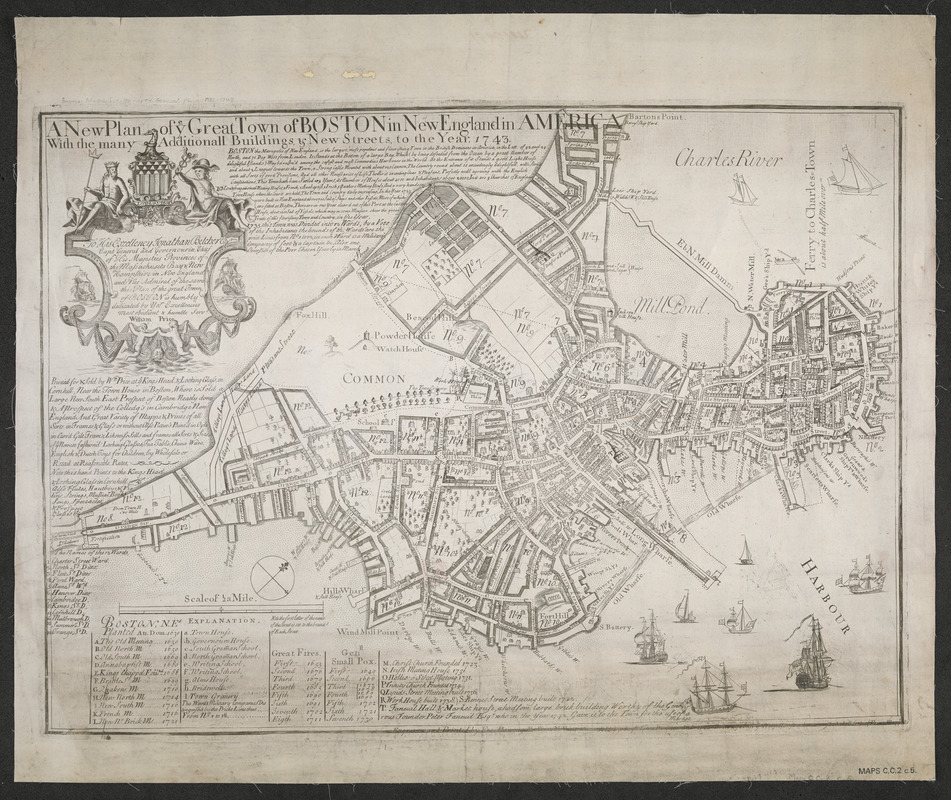
A new plan of ye great town of Boston in New England in America with the many additionall buildings & new streets to the year 1743
This map is also available in American Revolutionary Geographies Online (ARGO), a collections portal especially built for material relating to the American Revolutionary War Era. Visit ARGO to learn more about this item and explore the historical geography of North America in the late eighteenth century.
Item Information
- Title:
- A new plan of ye great town of Boston in New England in America with the many additionall buildings & new streets to the year 1743
- Creator:
- Bonner, John
- Publisher:
- Price, William
- Contributor:
- Dewing, Francis
- Date:
-
[1743]
- Format:
-
Maps/Atlases
- Location:
- British Library
- Collection (local):
-
British Library Collection
- Subjects:
-
Boston (Mass.)--Maps
- Places:
-
Suffolk (county)Boston
- Extent:
- 1 map ; 44x60cm.
- Terms of Use:
-
No known copyright restrictions.
This work is licensed for use under a Creative Commons Attribution Non-Commercial Share Alike License (CC BY-NC-SA).

- Publisher:
-
Boston :
Printed for & sold by Wm Price at ye Kings Head, & Looking Glass, in Cornhill ...
- Language:
-
English
- Catalog Record:
-
http://explore.bl.uk/BLVU1:LSCOP-ALL:BLL01005001920
- Notes:
-
A later state of the map first published by John Bonner in 1722. The original imprint has been defaced and reads 'Engraven and printed by Fra. Dewing. Boston N.E. 1722. Sold by Capt John Bonner and Willm Price against ye Town House where may be had all sorts of prints, mapps, &c'.
- Notes (date):
-
This date is inferred.


