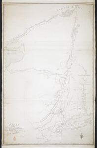
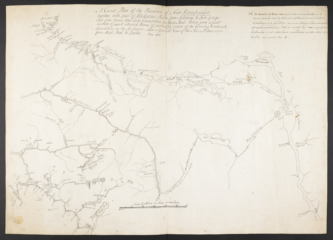
A Correct Plan of the Province of New Hampshire together with part of Hudsons River from Albany to Lake George and from thence thro' Lake Champlain to Mont Real: taken from a great number of exact attested Plans of particular parts of the Country & accurate observations of the Sea Coast. Also a General View of the River St Lawrence from Mont Real to Quebec
This map is also available in American Revolutionary Geographies Online (ARGO), a collections portal especially built for material relating to the American Revolutionary War Era. Visit ARGO to learn more about this item and explore the historical geography of North America in the late eighteenth century.
Item Information
- Title:
- A Correct Plan of the Province of New Hampshire together with part of Hudsons River from Albany to Lake George and from thence thro' Lake Champlain to Mont Real: taken from a great number of exact attested Plans of particular parts of the Country & accurate observations of the Sea Coast. Also a General View of the River St Lawrence from Mont Real to Quebec
- Former owner:
- George, III, King of Great Britain, 1738-1820
- Donor:
- George, IV, King of Great Britain, 1762-1830
- Name on Item:
-
June 1756.
- Date:
-
1756
- Format:
-
Maps/Atlases
Manuscripts
- Location:
- British Library
- Collection (local):
-
British Library Collection
- Subjects:
-
Fortification--Champlain, Lake--Early works to 1800
Champlain, Lake--Maps, Manuscript--Early works to 1800
New Hampshire--Maps, Manuscript--Early works to 1800
New York (State)--Maps, Manuscript--Early works to 1800
Vermont--Maps, Manuscript--Early works to 1800
Saint Lawrence River--Maps, Manuscript--Early works to 1800
United States--History--French and Indian War, 1754-1763--Maps, Manuscript--Early works to 1800
- Places:
-
New Hampshire
New York
Vermont
Saint Lawrence River
Champlain, Lake
- Extent:
- 1 map : manuscript pen and ink with watercolour and pencil ; 52 x 72 cm
- Terms of Use:
-
No known copyright restrictions.
This work is licensed for use under a Creative Commons Attribution Non-Commercial Share Alike License (CC BY-NC-SA).

- Scale:
-
Scale 1:633,600
- Language:
-
English
- Catalog Record:
-
http://explore.bl.uk/BLVU1:LSCOP-ALL:BLL01004987809
- Notes:
-
Relief is shown pictorially.
A "Scale of Miles 10 miles to an Inch" is given at the bottom of the map.
A text note at upper right reads "NB. The Branches of Rivers with single Strokes in the unsettled Parts of the Country are mostly drawn by Information of Persons who have travelled in the Wilderness, or by Conjecture ...". The note continues to act as a key identifying falls and churches.
Shows and names forts.
Shows a compass arrow in pencil orienting north to the right of the map.
The Norman B. Leventhal Centre at the Boston Public Library holds a copy of the map dated about 1880 (call number G3710).
A photographic reproduction of the map was auctioned January 23rd 1912 and January 24th 1912 (listed as lot number 1094 in the catalogue) at C. F. Libbie & Co. Book and Art Auctioneers located at 597 Washington Street in Boston. The catalogue description includes "photographic reproduction of a MS. map. 2 sheets, folio. Only a few copies so issued".
Titled "A drawn Plan of the Province of New Hampshire, together with part of Hudson's River from Albany to Lake George, and from thence through Lake Champlain to Mont Real: also a general View of the river St. Lawrence from Mont real to Quebec; June, 1756" in the Catalogue of Maps, Prints, Drawings, etc., forming the geographical and topographical collection attached to the Library of his late Majesty King George the third, etc., London, 1829.
Titled 'A "plan of the province of New Hampshire, together with part of Hudson's River, from Albany to Lake George, and from thence through Lake Champlain to Mont Real; taken from a great number of exact attested plans of particular parts of the country, and accurate observations on the sea coast; also a general view of the River St. Lawrence from Mont Real to Quebec, June, 1756; drawn on a scale of 10 miles to an inch": 2 f. 4 in. x 1 f. 8 in.' in the Catalogue of the manuscript maps, charts, and plans, and of the topographical drawings in the British Museum.
The map extends along the River St Lawrence from the mouth of the River Chaudière to Montreal, and southwards to Ipswich on the Atlantic Coast and Albany further west.

![[A map of Lake Champlain and Lake George, showing the route from Fort Edward to Montreal]](https://bpldcassets.blob.core.windows.net/derivatives/images/commonwealth:hx11z3312/image_thumbnail_300.jpg)
![[A colored map of the route between Albany and Oswego; drawn about 1756, on a scale of 2 miles to an inch]](https://bpldcassets.blob.core.windows.net/derivatives/images/commonwealth:hx11z3223/image_thumbnail_300.jpg)