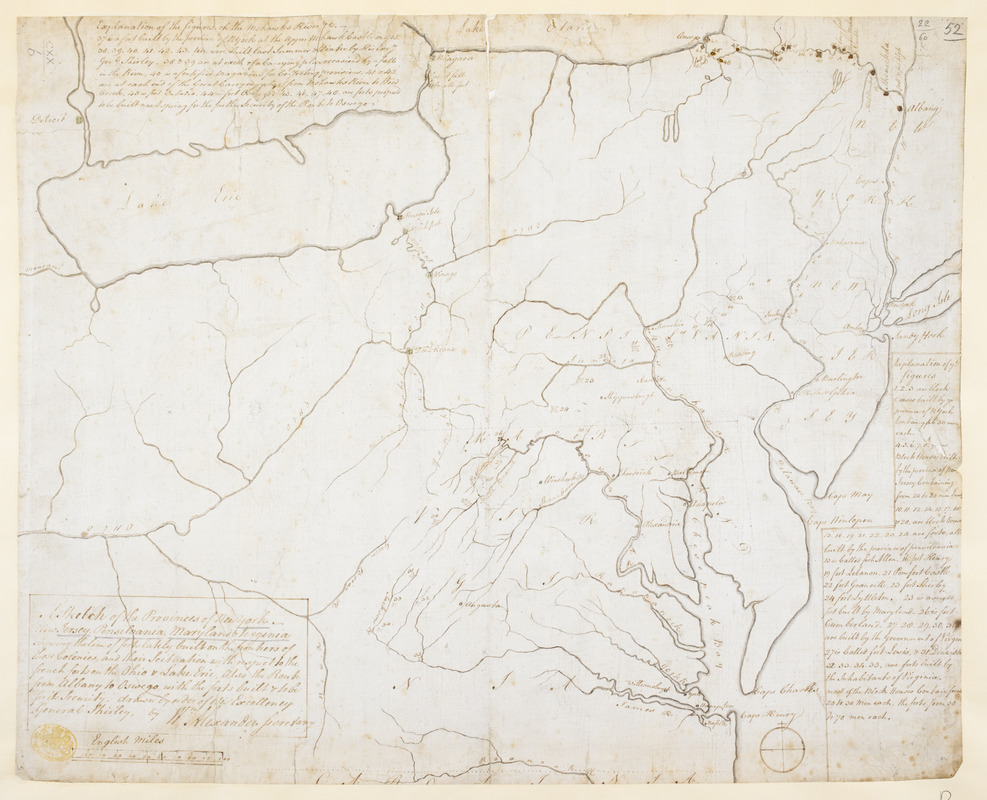
A Sketch of the Provinces of New York, New Jersey, Pensilvania, Maryland & Virginia shewing the line of forts lately built on the frontiers of those Colonies, and their Scituation with respect to the french forts on the Ohio & Lake Erie, Also the Route from Albany to Oswego with the forts built & to be for its Security
This map is also available in American Revolutionary Geographies Online (ARGO), a collections portal especially built for material relating to the American Revolutionary War Era. Visit ARGO to learn more about this item and explore the historical geography of North America in the late eighteenth century.
Item Information
- Title:
- A Sketch of the Provinces of New York, New Jersey, Pensilvania, Maryland & Virginia shewing the line of forts lately built on the frontiers of those Colonies, and their Scituation with respect to the french forts on the Ohio & Lake Erie, Also the Route from Albany to Oswego with the forts built & to be for its Security
- Cartographer:
- Alexander, William, 1726-1783
- Former owner:
- George, III, King of Great Britain, 1738-1820
- Donor:
- George, IV, King of Great Britain, 1762-1830
- Contributor:
- Shirley, William, 1694-1771
- Contributor:
- Eyre, William, active 1755
- Name on Item:
-
drawn by order of His Excellency General Shirley, by Wm. Alexander Secretary.
- Date:
-
1755
- Format:
-
Maps/Atlases
Manuscripts
- Location:
- British Library
- Collection (local):
-
British Library Collection
- Subjects:
-
Seven Years’ War, 1756-1763--Maps, Manuscript--Early works to 1800
Fortification--Middle Atlantic States--Maps, Manuscript--Early works to 1800
United States--History--French and Indian War, 1754-1763--Maps, Manuscript--Early works to 1800
Middle Atlantic States--Defenses--Maps, Manuscript--Early works to 1800
- Places:
-
Middle Atlantic (area)
- Extent:
- 1 map : manuscript pen and ink with watercolour ; 36 x 44 cm
- Terms of Use:
-
No known copyright restrictions.
This work is licensed for use under a Creative Commons Attribution Non-Commercial Share Alike License (CC BY-NC-SA).

- Scale:
-
Scale approximately 1:2,304,000
- Language:
-
English
- Catalog Record:
-
http://explore.bl.uk/BLVU1:LSCOP-ALL:BLL01004987656
- Notes:
-
A manuscript note on the map's verso in ink shows "Engin Eyre 1755".
Previous British Library cataloguings dates the map between 1757 and 1758.
Brown dates the map to 1756.
With a scale of "English Miles" at lower right, where 36.36 miles is equal to one inch.
Illustrating "a barrier of fortifications that would keep the French on the other side of the mountains" - Brown.
Shows 47 numbered forts and blockhouses.
Includes two short panels of explanatory text.
Titled "A drawn sketch of the Provinces of New York, New Jersey, Pensilvania, Maryland, and Virginia; shewing the line of Forts lately built on the Frontiers of those Colonies; and their situation with respect to the French Forts on the Ohio and Lake Erie: done by order of H.E. General Shirley by W. Alexander" in the Catalogue of Maps, Prints, Drawings, etc., forming the geographical and topographical collection attached to the Library of his late Majesty King George the third, etc., London, 1829.
Titled "A sketch of the provinces of New York, New Jersey, Pensilvania, Maryland, and Virginia, shewing the line of forts lately built on the frontiers of those Colonies, and their situation with respect to the French forts on the Ohio and Lake Erie; also the route from Albany to Oswego, with the forts built and to be built for its security; drawn by order of H. E. General Shirley, by W. Alexander, secretary;" on a scale of 36 English miles to an inch in the Catalogue of the manuscript maps, charts, and plans, and of the topographical drawings in the British Museum.

![[A colored map of the route between Albany and Oswego; drawn about 1756, on a scale of 2 miles to an inch]](https://bpldcassets.blob.core.windows.net/derivatives/images/commonwealth:hx11z3223/image_thumbnail_300.jpg)
![[A map of Fort Carillon and environs]](https://bpldcassets.blob.core.windows.net/derivatives/images/commonwealth:hx11z538d/image_thumbnail_300.jpg)
![[A map of Fort Carillon and environs]](https://bpldcassets.blob.core.windows.net/derivatives/images/commonwealth:hx11z342k/image_thumbnail_300.jpg)
![[A map of Lake Champlain and Lake George, showing the route from Fort Edward to Montreal]](https://bpldcassets.blob.core.windows.net/derivatives/images/commonwealth:hx11z3312/image_thumbnail_300.jpg)
