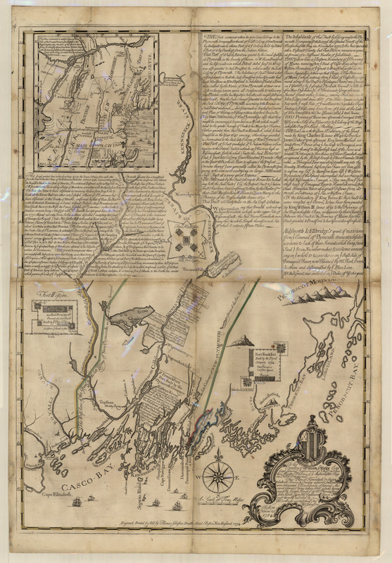
This plan of Kennebeck & Sagadahock Rivers & country adjacent
This map is also available in American Revolutionary Geographies Online (ARGO), a collections portal especially built for material relating to the American Revolutionary War Era. Visit ARGO to learn more about this item and explore the historical geography of North America in the late eighteenth century.
Item Information
- Title:
- This plan of Kennebeck & Sagadahock Rivers & country adjacent
- Title (alt.):
-
Plan of Kennebeck & Sagadahock Rivers
Plan of Kennebeck and Sagadahock Rivers
- Description:
-
Just a year after producing a map supporting the Brunswick Proprietors’ claim, Thomas Johnston issued this plan supporting the position of their opponents in the Plymouth Company. The map depicts the Company’s grant extending to Casco Bay and includes a long note justifying its title to the land. It also places the dispute in the broader context of Anglo-French tensions by highlighting the Company’s role in establishing Forts Franckfort and Western to protect the Maine frontier from French attacks.
- Creator:
- Johnston, Thomas, 1708-1767
- Contributor:
- Heath, Joseph
- Contributor:
- Jones, Phineas
- Contributor:
- North, John
- Contributor:
- Jones, Ephraim
- Contributor:
- Hutchinson, E.
- Contributor:
- Plymouth Company
- Name on Item:
-
is most humbly inscribed by ... Thos. Johnston.
- Date:
-
1754
- Format:
-
Maps/Atlases
- Location:
- Massachusetts Historical Society
- Collection (local):
-
Massachusetts Historical Society Collection
- Subjects:
-
Penobscot Bay (Me.)--Maps
New England--Maps
New York (State)--Maps
Maine--Maps
New Hampshire--Maps
Kennebec River--Maps
Kennebec Patent--Maps
Casco Bay (Me.)--Maps
- Places:
-
MainePenobscot (bay)
New York
New Hampshire
MaineKennebec (river)
MaineCumberland (county)Casco Bay
- Extent:
- 1 map : col. ; 84 x 61 cm.
- Terms of Use:
-
No known copyright restrictions.
This work is licensed for use under a Creative Commons Attribution Non-Commercial Share Alike License (CC BY-NC-SA).

- Publisher:
-
[Boston] :
Engraved, printed & sold by Thomas Johnston, Brattle Street, Boston, New England
- Scale:
-
Scale 1:253,440
- Language:
-
English
- Catalog Record:
-
http://balthazaar.masshist.org/cgi-bin/Pwebrecon.cgi?DB=local&BBID=106609
- Notes:
-
Latitude in degrees and minutes north from equator. Latitude and longitude also given for inset map.
Coordinates indicated.
Boundaries of British claims in yellow, green and red.
Title within decorative cartouche.
At head of title: To his Excellency William Shirley Esq. Capt. General & Governour in Chief in & over his Majesty's Province of ye Massachusetts Bay in New England.
Issued by Plymouth Company.
Includes three columns of text asserting grounds for British claims to sovereignty over province of Maine and controverting French claims.
Includes inset map of New England "chiefly taken from Monsr. Bellin's Map of North America published at Paris 1745."
Includes plans of Fort Western, Fort Hallifax [sic], and Fort Frankfort.
- Notes (exhibitions):
-
Exhibited: "Made in Boston" organized by the Norman B. Leventhal Map Center at the Boston Public Library, 2013-2014.


