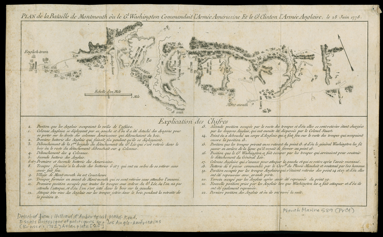
Plan de la bataille de Montmouth où le Gl. Washington commandait l'armeé Americaine et le Gl. Clinton l'armeé Anglaise, le 28 Juin 1778
This map is also available in American Revolutionary Geographies Online (ARGO), a collections portal especially built for material relating to the American Revolutionary War Era. Visit ARGO to learn more about this item and explore the historical geography of North America in the late eighteenth century.
Item Information
- Title:
- Plan de la bataille de Montmouth où le Gl. Washington commandait l'armeé Americaine et le Gl. Clinton l'armeé Anglaise, le 28 Juin 1778
- Title (alt.):
-
Plan de la bataille de Monmouth
- Date:
-
[1782]
- Format:
-
Maps/Atlases
- Location:
- Newberry Library
- Collection (local):
-
Roger S. Baskes Collection
- Subjects:
-
Monmouth, Battle of, Freehold, N.J., 1778--Maps--Early works to 1800
- Places:
-
New JerseyMonmouth (county)Freehold
- Extent:
- 1 map : hand col. ; 11 x 39 cm., on sheet 26 x 42 cm.
- Terms of Use:
-
No known copyright restrictions.
Contact host institution for more information.
- Scale:
-
Scale [ca. 1:30,500]
- Language:
-
French
- Catalog Record:
-
https://i-share-nby.primo.exlibrisgroup.com/permalink/01CARLI_NBY/i5mcb2/alma999474068805867
- Notes:
-
Explication des chifres in bottom margin keyed to 22 references.
Detached from the untitled atlas accompanying: Hilliard d'Auberteuil, Michel-René. Essais historiques et politiques sur les Anglo-Américains (Brussels, 1782), [plate 20].
- Notes (date):
-
This date is inferred.
- Call #:
-
French Marine 589
- LCCN:
-
gm 71000924
![[Campement] de l'armée franc̦oise [devant u]n village des ennemis, les Chicachas le 26 [de mais] 1736](https://bpldcassets.blob.core.windows.net/derivatives/images/commonwealth:z603vn65v/image_thumbnail_300.jpg)
