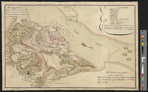
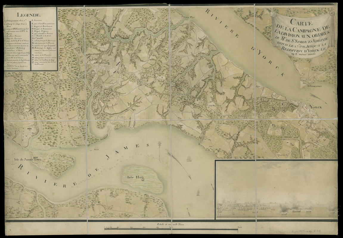
Carte de la campagne de la division aux ordres du Mis. de St. Simon en Virginie depuis le 2 7bre. 1781 jusq-a la reddition d'Yorck le 19 8bre. meme année
This map is also available in American Revolutionary Geographies Online (ARGO), a collections portal especially built for material relating to the American Revolutionary War Era. Visit ARGO to learn more about this item and explore the historical geography of North America in the late eighteenth century.
Item Information
- Title:
- Carte de la campagne de la division aux ordres du Mis. de St. Simon en Virginie depuis le 2 7bre. 1781 jusq-a la reddition d'Yorck le 19 8bre. meme année
- Description:
-
Anonymous map of the Yorktown and Williamsburg regions on the Virginia Peninsula possibly compiled by a French engineer named D'Aboville serving under General Claude Anne de Rouvroy, Marquis de Saint-Simon Montblern; see historian Martha McCartney's email correspondence of June 2005 (filed in the Newberry Library Map Information File.) Shows troop movements made between July 2 and October 8, 1781 in coordination with American forces against the British army during the Yorktown siege. Map legend keyed to sites 1-12 and A-Q. Identifies camps, fortifications, and earthworks. Topographic detail includes wooded areas, cultivated fields, individual buildings, and roads. Includes inset view of Yorktown (113 x 248 mm.)
- Contributor:
- D'Aboville, fl. 1781
- Date:
-
1781
- Format:
-
Maps/Atlases
Manuscripts
- Location:
- Newberry Library
- Collection (local):
-
Edward E. Ayer Manuscript Map Collection
- Subjects:
-
Yorktown (Va.)--History--Siege, 1781--Maps
Yorktown Region (Va.)--Maps--Early works to 1800
Williamsburg Region (Va.)--Maps--Early works to 1800
Virginia Peninsula (Va.)--Maps--Early works to 1800
Yorktown (Va.)--Pictorial works--Early works to 1800
Saint Simon, Claude Anne, Duc de, 1740-1819
- Places:
-
VirginiaYork (county)Yorktown
- Extent:
- 1 ms. map : hand col. ; 422 x 673 mm.
- Terms of Use:
-
No known copyright restrictions.
Contact host institution for more information.
- Scale:
-
Scale [ca. 1:43,500]
- Language:
-
French
- Catalog Record:
-
https://i-share-nby.primo.exlibrisgroup.com/permalink/01CARLI_NBY/i5mcb2/alma991447198805867
- Notes:
-
Relief shown by shading and hachures.
Pen-and-ink, watercolor and wash (green, blue, brown, yellow); sectioned into 8 panels, mounted on cloth.
- Call #:
-
Ayer MS map 238 (NLO)