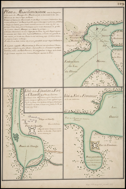
Plan de Missilimakinak avec la description de la route du Missisipi ; Idée de la situation du fort de Chambly, et des ses environs ; Idée du fort de Frontenac et de ses environs
This map is also available in American Revolutionary Geographies Online (ARGO), a collections portal especially built for material relating to the American Revolutionary War Era. Visit ARGO to learn more about this item and explore the historical geography of North America in the late eighteenth century.
Item Information
- Title:
- Plan de Missilimakinak avec la description de la route du Missisipi ; Idée de la situation du fort de Chambly, et des ses environs ; Idée du fort de Frontenac et de ses environs
- Title (alt.):
-
Plan de Michilimackinac avec la description de la route du Mississippi
- Description:
-
Details the Straits of Mackinac region, including the fort and Indian village at Saint Ignace and the fort established across the Straits at latter-day Mackinaw City; 16 lines of accompanying notes mention the presence of 600 couriers de bois in 1716. For English translation of the notes (by Katherine Stebbins), see Map Information File. On same sheet with maps of the Fort Chambly in Québec and Fort Frontenac (later the site of Kingston, Ontario).
- Date:
-
[1717]
- Format:
-
Maps/Atlases
Manuscripts
- Location:
- Newberry Library
- Collection (local):
-
Everett D. Graff Collection of Western Americana
- Subjects:
-
Fortification--Michigan--Mackinaw City--Maps--Early works to 1800
Fort Michilimackinac (Mackinaw City, Mich.)
Fortification--Michigan--Saint Ignace--Maps--Early works to 1800
Fortification--Québec--Chambly--Maps--Early works to 1800
Fortification--Ontario--Fort Frontenac (Fort)--Maps--Early works to 1800
Indians of North America--Michigan--Saint Ignace--Maps--Early works to 1800
Nautical charts--Michigan--Mackinac, Straits of--Early works to 1800
Manuscript maps--Early works to 1800
Mackinac, Straits of (Mich.)--Maps--Early works to 1800
Fort Michilimackinac (Mackinaw City, Mich.)--Maps--Early works to 1800
Mackinaw City (Mich.)--Maps--Early works to 1800
Saint Ignace (Mich.)--Maps--Early works to 1800
Chambly (Québec)--Maps--Early works to 1800
Fort Frontenac (Ont. : Fort)--Maps--Early works to 1800
Kingston (Ont.)--Maps--Early works to 1800
- Places:
-
CanadaOntario (province)Kingston
CanadaQuebec (province)Chambly
MichiganMackinac (county)Saint Ignace
MichiganEmmet (county)Mackinaw City
Straits of Mackinac
- Extent:
- 3 ms. maps : hand col. ; 270 x 178 mm. and smaller, on sheet 560 x 374 mm.
- Terms of Use:
-
No known copyright restrictions.
Contact host institution for more information.
- Scale:
-
Scale not given
- Language:
-
French
- Catalog Record:
-
https://i-share-nby.primo.exlibrisgroup.com/permalink/01CARLI_NBY/i5mcb2/alma991814978805867
- Notes:
-
Sheet 109 of 115 (i.e. 117; includes sheets 71A and 106A) numbered leaves in the Cartes Marines Manuscript Map Collection, detailing French colonial interests worldwide, ca. 1640-ca. 1726.
Pen-and-ink and watercolor (green, grey, brown, yellow, red); mounted on cloth.
- Notes (date):
-
This date is inferred.
- Call #:
-
Ayer MS map 30 sheet 109