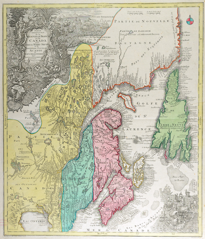
Partie orientale de la Nouvelle France ou du Canada : avec l'isle de Terre-Neuve et de Nouvelle Escosse, Acadie et Nouv. Angleterre avec fleuve de St. Laurence
This map is also available in American Revolutionary Geographies Online (ARGO), a collections portal especially built for material relating to the American Revolutionary War Era. Visit ARGO to learn more about this item and explore the historical geography of North America in the late eighteenth century.
Item Information
- Title:
- Partie orientale de la Nouvelle France ou du Canada : avec l'isle de Terre-Neuve et de Nouvelle Escosse, Acadie et Nouv. Angleterre avec fleuve de St. Laurence
- Creator:
- Lotter, Tobias Conrad, 1717-1777
- Contributor:
- Seutter, Albrecht Carl, 1722-1762
- Name on Item:
-
representé par T. Conr. Lotter, graveur et géogr. d'Augsbourg ; dresse par Alb. Charl. Seutter, géogr., Tob. Conr. Lotter, sc.
- Date:
-
[1756–1762]
- Format:
-
Maps/Atlases
- Location:
- Boston Athenaeum
- Collection (local):
-
Cartographic Collection
- Subjects:
-
Canada--Maps--Early works to 1800
New France--Maps--Early works to 1800
- Places:
-
Canada
- Extent:
- 1 map : col. ; 56 x 48 cm.
- Terms of Use:
-
No known copyright restrictions.
This work is licensed for use under a Creative Commons Attribution Non-Commercial Share Alike License (CC BY-NC-SA).

- Publisher:
-
Augsbourg? :
[s.n.]
- Scale:
-
Scale ca. 1:1,100,000
- Language:
-
French
- Catalog Record:
-
http://catalog.bostonathenaeum.org/vwebv/holdingsInfo?bibId=473171
- Notes:
-
Hand colored in yellow, pink, and green.
Relief shown pictorially.
- Notes (date):
-
This date is inferred.
- LCCN:
-
73695764


