Plan of Worcester
This map is also available in American Revolutionary Geographies Online (ARGO), a collections portal especially built for material relating to the American Revolutionary War Era. Visit ARGO to learn more about this item and explore the historical geography of North America in the late eighteenth century.
Item Information
- Title:
- Plan of Worcester
- Description:
-
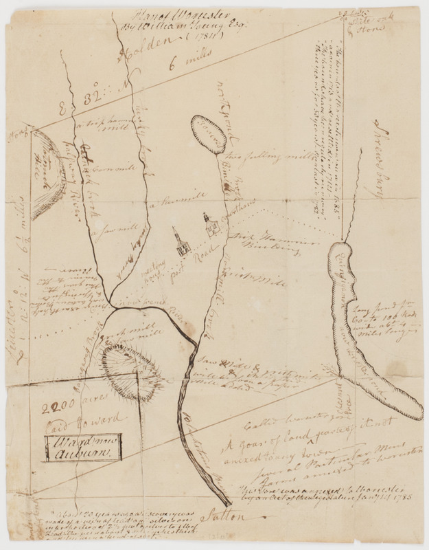
Subject: Map of the city of Worcester showing the post road, buildings and meeting houses. Later additions show the Blackstone River and Canal and notes that the town of Ward is now known as Auburn.
- Creator:
- Young, William, 1714-1795
- Name on Item:
-
by William Young Esq. (1784)
- Date:
-
[1784]
- Format:
-
Maps/Atlases
Manuscripts
- Location:
- American Antiquarian Society
- Collection (local):
-
American Antiquarian Society Collection
- Subjects:
-
Worcester (Mass.)--Maps
- Places:
-
Worcester (county)
- Extent:
- 1 map : ink ; 25 x 20 cm.
- Terms of Use:
-
Public Domain/No known restrictions on use. Contact host institution to download image.
Contact host institution for more information.
- Scale:
-
Scale not given
- Language:
-
English
- Catalog Record:
-
http://catalog.mwa.org/vwebv/holdingsInfo?bibId=493305
- Notes:
-
Originally drawn in 1784. Has additions added after 1837.
- Notes (date):
-
This date is inferred.