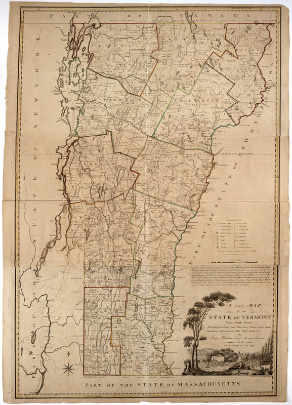
A correct map of the state of Vermont from actual survey; : exhibiting the county andtown lines, rivers, lakes, ponds
This map is also available in American Revolutionary Geographies Online (ARGO), a collections portal especially built for material relating to the American Revolutionary War Era. Visit ARGO to learn more about this item and explore the historical geography of North America in the late eighteenth century.
Item Information
- Title:
- A correct map of the state of Vermont from actual survey; : exhibiting the county andtown lines, rivers, lakes, ponds
- Description:
-
Subject: Map of the state of Vermont with county lines outlined in different colors. Cartouche at bottom shows a farm scene with figures walking behind a cart filled with hay, cows grazing, and sheep sleeping in a field. A farmhouse is seen behind the trees.
- Creator:
- Whitelaw, James, 1748-1829
- Engraver:
- Doolittle, Amos, 1754-1832
- Name on Item:
-
By James Whitelaw Esqr.: surveyor general. 1796. ; Engraved by Amos Doolittle New Haven 1796.
- Date:
-
[1796]
- Format:
-
Maps/Atlases
- Location:
- American Antiquarian Society
- Collection (local):
-
American Antiquarian Society Collection
- Subjects:
-
Farms--Pictorial works
Vermont--Maps
- Places:
-
Vermont
- Extent:
- 1 map on 3 sheets : engraving, hand-col. ; 114 x 77 cm., 116 x 83 cm., sheets 39 x 83 cm.
- Terms of Use:
-
Public Domain/No known restrictions on use. Contact host institution to download image.
Contact host institution for more information.
- Publisher:
-
New Haven :
[s.n.]
- Scale:
-
Scale [ca. 1:253,440]
- Language:
-
English
- Catalog Record:
-
http://catalog.mwa.org/vwebv/holdingsInfo?bibId=462351
- Notes:
-
Prime meridians: Washington and London.
Relief shown by hachures.
State no. I.
"With privilege of copy right."
"Note."
- Notes (date):
-
This date is inferred.


