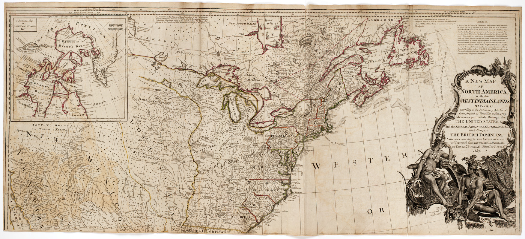
A New map of North America : with the West India Islands. : Divided according to the preliminary articles of Peace, signed at Versailles, 20 Jan. 1783. Wherein are particularly distinguished the United States, and the several provinces, governments &ca. : Which compose the British dominions; laid down according to the latest surveys, and corrected from the original materials, of Goverr. Pownall membr. of Paliamt. 1783
This map is also available in American Revolutionary Geographies Online (ARGO), a collections portal especially built for material relating to the American Revolutionary War Era. Visit ARGO to learn more about this item and explore the historical geography of North America in the late eighteenth century.
Item Information
- Title:
- A New map of North America : with the West India Islands. : Divided according to the preliminary articles of Peace, signed at Versailles, 20 Jan. 1783. Wherein are particularly distinguished the United States, and the several provinces, governments &ca. : Which compose the British dominions; laid down according to the latest surveys, and corrected from the original materials, of Goverr. Pownall membr. of Paliamt. 1783
- Description:
-
Map of North America showing Canada, United States, Mexico, Central America and the West Indies. Also shows the locations of the various Native American tribes. Cartouche at upper right shows a Native American man, woman and child. The man and woman each hold quivers, and the woman holds a bow.
- Publisher:
- Sayer, Robert, 1725-1794
- Date:
-
[1786?]
- Format:
-
Maps/Atlases
- Location:
- American Antiquarian Society
- Collection (local):
-
American Antiquarian Society Collection
- Subjects:
-
Indians of North America--Pictorial works
North America--Maps
- Places:
-
North America (area)
- Extent:
- 1 map on 4 sheets : engraving, hand colored ; 102 x 116 cm., on sheets 53 x 60 cm. or smaller
- Terms of Use:
-
No known copyright restrictions.
This work is licensed for use under a Creative Commons Attribution Non-Commercial Share Alike License (CC BY-NC-SA).

- Publisher:
-
[London] :
Printed for Robt. Sayer, map, chart & printseller, no. 53 Fleet Street, as the Act directs
- Scale:
-
Scale [ca. 1:5,000,000]
- Language:
-
English
- Catalog Record:
-
http://catalog.mwa.org/vwebv/holdingsInfo?bibId=488966
- Notes:
-
Prime meridian: London and Ferro.
Relief shown pictorially.
Inset: A particular map of Baffin and Hudson's Bay.
Inset: The passage by land to California discovered by Father Eusebius Francis Kino ...
- Identifier:
-
488966_0001


