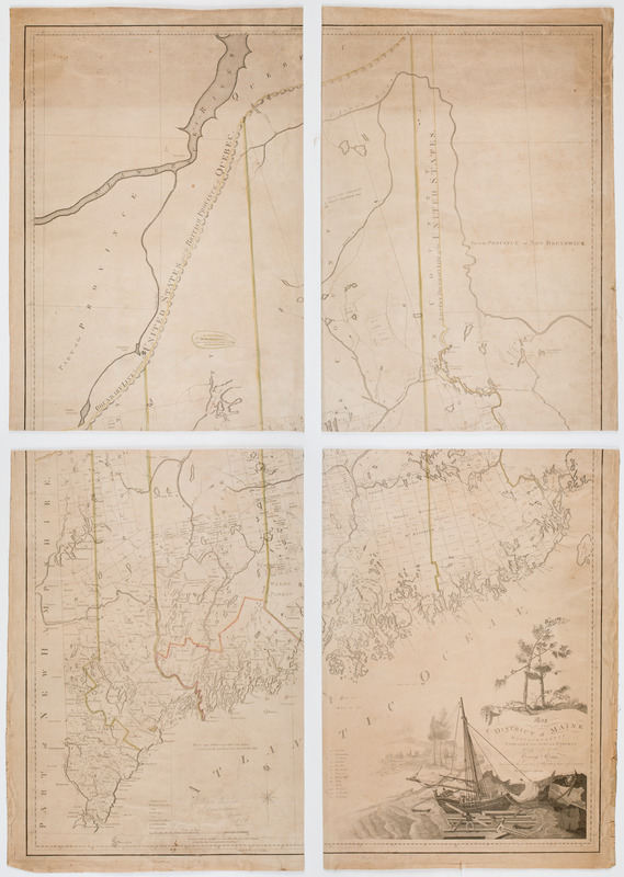
Map of the District of Maine Massachusetts : compiled from actual surveys made by order of the General Court, and under the inspection of agents of their appointment
This map is also available in American Revolutionary Geographies Online (ARGO), a collections portal especially built for material relating to the American Revolutionary War Era. Visit ARGO to learn more about this item and explore the historical geography of North America in the late eighteenth century.
Item Information
- Title:
- Map of the District of Maine Massachusetts : compiled from actual surveys made by order of the General Court, and under the inspection of agents of their appointment
- Description:
-
Subject: Map of the District of Maine. Cartouche shows men loading lumber onto a ship off of the shore, and a town is seen at left, and a forest is depicted above.
- Creator:
- Carleton, Osgood, 1742-1816
- Engraver:
- Hill, Samuel, approximately 1766-1804
- Engraver:
- Callender, Joseph, 1751-1821
- Artist:
- Graham, George, active 1788-1813
- Name on Item:
-
By Osgood Carleton. ; Engraved by J. Callender & S. Hill Boston.
- Date:
-
[ca. 1799]
- Format:
-
Maps/Atlases
- Location:
- American Antiquarian Society
- Collection (local):
-
American Antiquarian Society Collection
- Subjects:
-
Maine--Maps
- Places:
-
Maine
- Extent:
- 1 map on 4 sheets : engraving ; 132 x 92 cm., on sheets 67 x 47 cm.
- Terms of Use:
-
Public Domain/No known restrictions on use. Contact host institution to download image.
Contact host institution for more information.
- Publisher:
-
Boston :
[s.n.]
- Scale:
-
Scale [ca. 1:506,880]
- Language:
-
English
- Catalog Record:
-
http://catalog.mwa.org/vwebv/holdingsInfo?bibId=476356
- Notes:
-
Prime meridian: London and Washington, D.C.
Relief shown by hachures.
First state.
Cartouche signed: Drawn by G. Graham.
"N.B. As the surveys of some towns were not so full as others, the roads & streams of those towns have been intentionally discontinued."

![[Map of the area along the Saint Croix River in Maine and New Brunswick]](https://bpldcassets.blob.core.windows.net/derivatives/images/commonwealth:6108vt00n/image_thumbnail_300.jpg)


