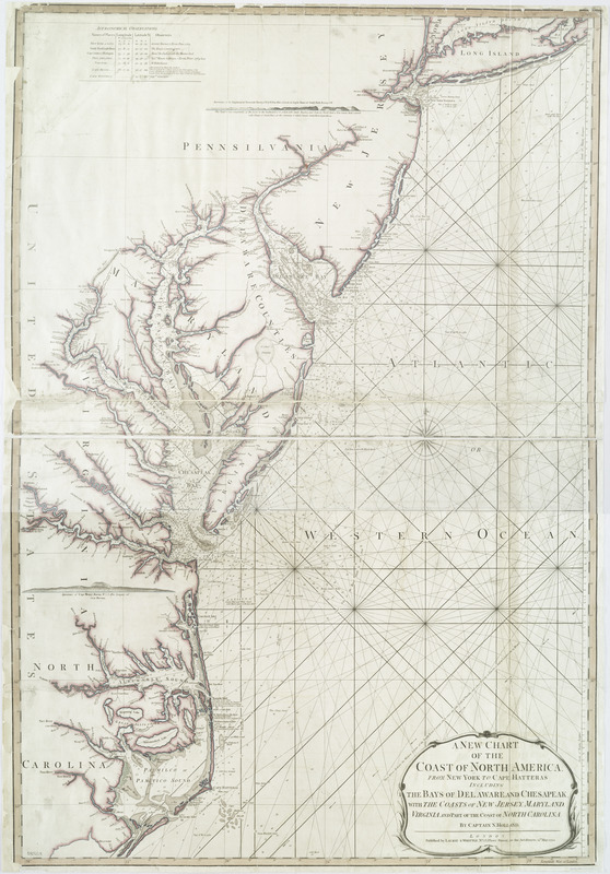
A new chart of the coast of North America : from New York to Cape Hatteras, including the bays of Delaware and Chesapeak, with the coasts of New Jersey, Maryland, Virginia and part of the coast of North Carolina
This map is also available in American Revolutionary Geographies Online (ARGO), a collections portal especially built for material relating to the American Revolutionary War Era. Visit ARGO to learn more about this item and explore the historical geography of North America in the late eighteenth century.
Item Information
- Title:
- A new chart of the coast of North America : from New York to Cape Hatteras, including the bays of Delaware and Chesapeak, with the coasts of New Jersey, Maryland, Virginia and part of the coast of North Carolina
- Creator:
- Holland, N., Captain
- Contributor:
- Robert Laurie and James Whittle
- Name on Item:
-
by Captain N. Holland.
- Date:
-
1794
- Format:
-
Maps/Atlases
- Location:
- New York Public Library
- Collection (local):
-
Maps of North America
- Subjects:
-
Atlantic Coast (Middle Atlantic States)--Maps--Early works to 1800
Atlantic Coast (N.C.)--Maps--Early works to 1800
Nautical charts--Atlantic Coast (Middle Atlantic States)--Early works to 1800
Nautical charts--North Carolina--Atlantic Coast--Early works to 1800
- Places:
-
North Carolina
Middle Atlantic (area)
- Extent:
- 1 map : hand col. ; 103 x 70 cm.
- Terms of Use:
-
No known copyright restrictions.
This work is licensed for use under a Creative Commons Attribution Non-Commercial Share Alike License (CC BY-NC-SA).

- Publisher:
-
London :
Published by Laurie & Whittle, No. 53 Fleet Street, as the Act directs
- Scale:
-
Scale [ca. 1:710,000]
- Language:
-
English
- Catalog Record:
-
https://digitalcollections.nypl.org/items/510d47da-f06b-a3d9-e040-e00a18064a99
- Notes:
-
Partial relief shown by hachures and pictorially. Depths shown by soundings.
Prime meridian: London.
Includes "Astronomical observations," notes, and 2 coastal panoramas.


