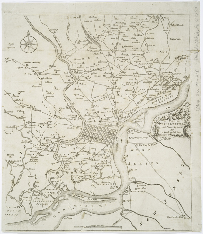
A map of Philadelphia and parts adjacent
This map is also available in American Revolutionary Geographies Online (ARGO), a collections portal especially built for material relating to the American Revolutionary War Era. Visit ARGO to learn more about this item and explore the historical geography of North America in the late eighteenth century.
Item Information
- Title:
- A map of Philadelphia and parts adjacent
- Creator:
- Scull, Nicholas, 1686?-1761?
- Contributor:
- Heap, George, active 1715-1760
- Name on Item:
-
by N. Scull and G. Heap.
- Date:
-
[1753]
- Format:
-
Maps/Atlases
- Location:
- New York Public Library
- Collection (local):
-
Maps of North America
- Subjects:
-
Philadelphia Region--Maps--Early works to 1800
Philadelphia (Pa.)--Maps--Early works to 1800
- Places:
-
Philadelphia (county)Philadelphia
- Extent:
- 1 map ; 35 x 30 cm.
- Terms of Use:
-
No known copyright restrictions.
This work is licensed for use under a Creative Commons Attribution Non-Commercial Share Alike License (CC BY-NC-SA).

- Publisher:
-
[S.l.] :
[s.n.]
- Scale:
-
Scale [ca. 1:65,000]
- Language:
-
English
- Catalog Record:
-
https://digitalcollections.nypl.org/items/510d47da-f00a-a3d9-e040-e00a18064a99
- Notes:
-
From Gentleman's Magazine, vol. 23, 1753 p. 373.
Includes table of distances "The distances of particular places in this map, from the court house."
Mounted on paper with linen backing.
- Notes (date):
-
This date is inferred.
- LCCN:
-
2010587015

![[Environs of Philadelphia]](https://bpldcassets.blob.core.windows.net/derivatives/images/commonwealth:7h149x76d/image_thumbnail_300.jpg)

