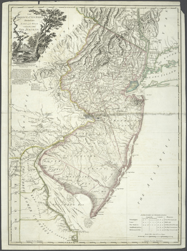
The Province of New Jersey : divided into East and West, commonly called the Jerseys
This map is also available in American Revolutionary Geographies Online (ARGO), a collections portal especially built for material relating to the American Revolutionary War Era. Visit ARGO to learn more about this item and explore the historical geography of North America in the late eighteenth century.
Item Information
- Title:
- The Province of New Jersey : divided into East and West, commonly called the Jerseys
- Creator:
- Faden, William, 1749-1836
- Contributor:
- Ratzer, Bernard.
- Contributor:
- Bancker, Gerard, 1740-1799
- Name on Item:
-
Engraved & published by Wm. Faden.
- Date:
-
1778
- Format:
-
Maps/Atlases
- Location:
- New York Public Library
- Collection (local):
-
Lawrence H. Slaughter Collection of English maps, charts, globes, books and atlases
- Subjects:
-
New Jersey--Maps--Early works to 1800
New Jersey--Administrative and political divisions--Maps--Early works to 1800
- Places:
-
New Jersey
- Extent:
- 1 map : col. ; 78 x 57 cm.
- Terms of Use:
-
No known copyright restrictions.
This work is licensed for use under a Creative Commons Attribution Non-Commercial Share Alike License (CC BY-NC-SA).

- Publisher:
-
[London] :
Wm. Faden
- Edition:
- 2d ed. with considerable improvements
- Scale:
-
Scale [ca. 1:420,000]
- Language:
-
English
- Catalog Record:
-
https://digitalcollections.nypl.org/items/510d47db-c689-a3d9-e040-e00a18064a99
- Notes:
-
Hand colored.
Prime meridian: Philadelphia.
Relief shown by hachures.
Shows county boundaries and "Division line run in 1743 between East New Jersey and West New Jersey."
"This map has been drawn from the survey made in 1769 ... by Bernard Ratzer ... and from another large survey of the northern parts ... by Gerard Banker."
"In this second edition great use has been made of several military surveys generously communicated by officers of the British troops and of the regiments of Hesse and Anspach."
Includes table of "Astronomical observations."
- LCCN:
-
74692518


