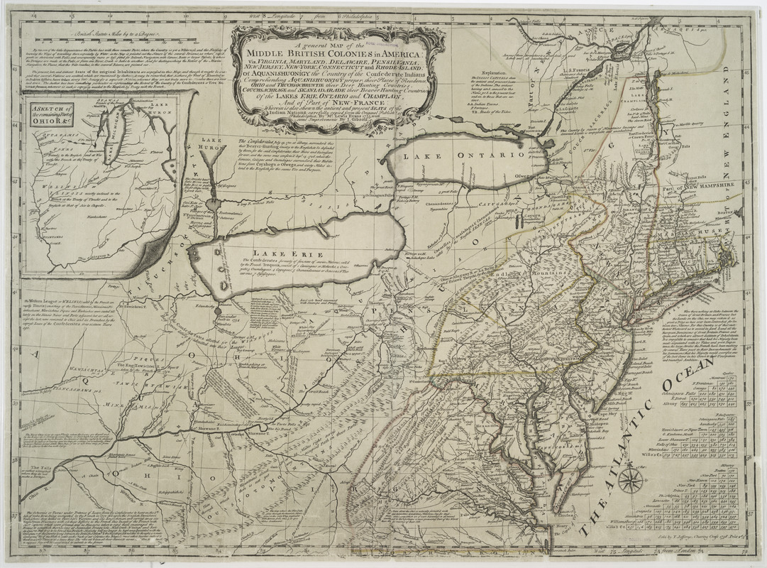
A general map of the middle British colonies in America : Viz. Virginia, Maryland, Delaware, Pensilvania, New-Jersey, New-York, Connecticut and Rhode-Island: Of Aquanishuonigy the country of the confederate Indians comprehending Aquanishuonigy proper, their places of residence, Ohio and Thuchsochruntie their deer hunting countries, Couchsachrage and Skaniadarade their beaver hunting countries, of the Lakes Erie, Ontario and Champlain, and of part of New France: Wherein is also shewn the antient and present seats of the Indian nations
This map is also available in American Revolutionary Geographies Online (ARGO), a collections portal especially built for material relating to the American Revolutionary War Era. Visit ARGO to learn more about this item and explore the historical geography of North America in the late eighteenth century.
Item Information
- Title:
- A general map of the middle British colonies in America : Viz. Virginia, Maryland, Delaware, Pensilvania, New-Jersey, New-York, Connecticut and Rhode-Island: Of Aquanishuonigy the country of the confederate Indians comprehending Aquanishuonigy proper, their places of residence, Ohio and Thuchsochruntie their deer hunting countries, Couchsachrage and Skaniadarade their beaver hunting countries, of the Lakes Erie, Ontario and Champlain, and of part of New France: Wherein is also shewn the antient and present seats of the Indian nations
- Title (alt.):
-
Middle British colonies
- Creator:
- Gibson, J. (John), active 1750-1792
- Publisher:
- Jefferys, Thomas, -1771
- Contributor:
- Evans, Lewis, 1700?-1756
- Name on Item:
-
carefully copied from the original published at Philadelphia, by Mr. Lewis Evans 1755, with some improvements by I. Gibson.
- Date:
-
1758
- Format:
-
Maps/Atlases
- Location:
- New York Public Library
- Collection (local):
-
Maps of North America
- Subjects:
-
Northeastern States--Maps--Early works to 1800
North America--Maps--Early works to 1800
British--America--Maps--Early works to 1800
- Places:
-
Northeastern United States (area)
North America (area)
- Extent:
- col. map 49 x 67 cm.
- Terms of Use:
-
No known copyright restrictions.
This work is licensed for use under a Creative Commons Attribution Non-Commercial Share Alike License (CC BY-NC-SA).

- Publisher:
-
[London] :
Sold by T. Jefferys
- Scale:
-
Scale ca. 1:2,250,000
- Language:
-
English
- Catalog Record:
-
https://digitalcollections.nypl.org/items/510d47df-f8bd-a3d9-e040-e00a18064a99
- Notes:
-
Hand colored.
Relief shown pictorially.
Shows "West longitude from London" and "from Philadelphia."
- LCCN:
-
74694120


