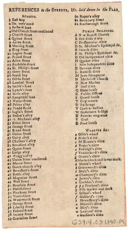
References to the streets, &c. laid down in the plan : [of the city of Charleston, South Carolina]
This map is also available in American Revolutionary Geographies Online (ARGO), a collections portal especially built for material relating to the American Revolutionary War Era. Visit ARGO to learn more about this item and explore the historical geography of North America in the late eighteenth century.
Item Information
- Title:
- References to the streets, &c. laid down in the plan : [of the city of Charleston, South Carolina]
- Author:
- Petrie, E. (Edmund)
- Publisher:
- Milligan, Jacob
- Date:
-
1790
- Format:
-
Books
- Location:
- Harvard Library
- Collection (local):
-
Harvard Map Collection
- Subjects:
-
Charleston (S.C.)
- Places:
-
Charleston (county)Charleston
- Extent:
- 1 sheet
- Terms of Use:
-
No known copyright restrictions.
This work is licensed for use under a Creative Commons Attribution Non-Commercial Share Alike License (CC BY-NC-SA).

- Publisher:
-
[Charleston, S.C.] :
[J. Milligan]
- Language:
-
English
- Catalog Record:
-
http://id.lib.harvard.edu/aleph/010131465/catalog
- Notes:
-
References for Plan of the city of Charleston, South Carolina.
In The Charleston directory and revenue system. Charleston : Printed by T.B. Bowen no, . 42 Bay. Sold by J. Milligan, at the Intelligence Office, [1790].
- Identifier:
-
44452187