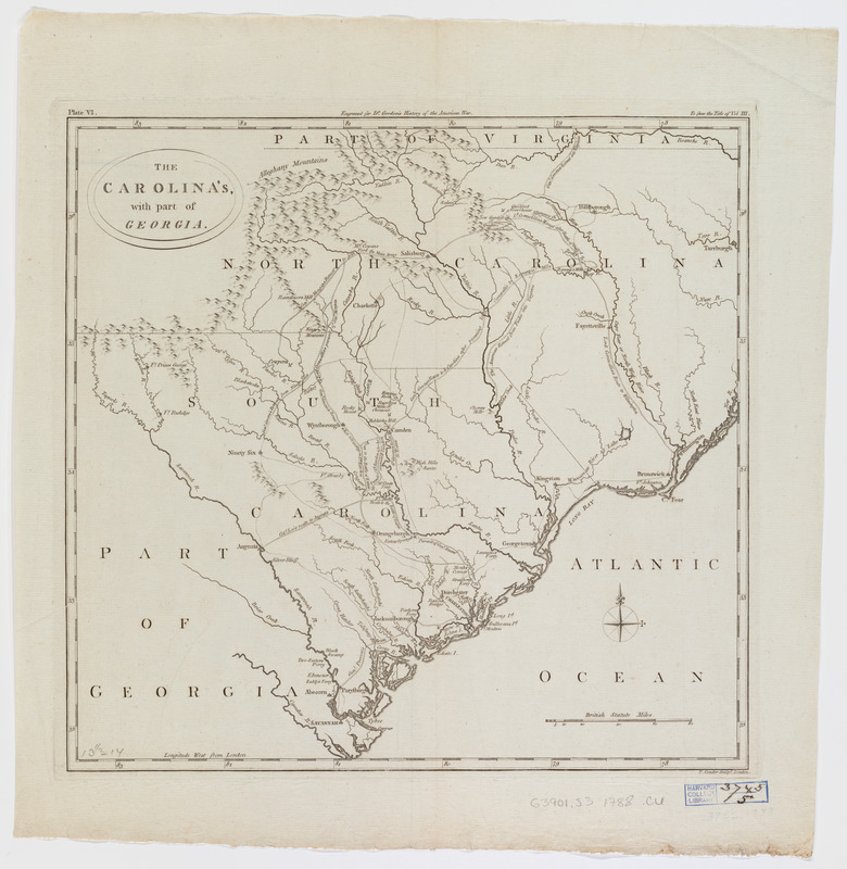
The Carolina's with part of Georgia
This map is also available in American Revolutionary Geographies Online (ARGO), a collections portal especially built for material relating to the American Revolutionary War Era. Visit ARGO to learn more about this item and explore the historical geography of North America in the late eighteenth century.
Item Information
- Title:
- The Carolina's with part of Georgia
- Title (alt.):
-
Carlolinas with part of Georgia
- Creator:
- Conder, Thomas, 1746 or 1747-1831
- Contributor:
- Gordon, William, 1728-1807
- Contributor:
- Dilly, Charles, 1739-1807
- Contributor:
- Buckland, James, 1710 or 1711-1790
- Name on Item:
-
T. Conder, sculpt.
- Date:
-
[1788]
- Format:
-
Maps/Atlases
- Location:
- Harvard Library
- Collection (local):
-
Harvard Map Collection
- Subjects:
-
North Carolina--History--Revolution, 1775-1783--Maps--Early works to 1800
South Carolina--History--Revolution, 1775-1783--Maps--Early works to 1800
Georgia--History--Revolution, 1775-1783--Maps--Early works to 1800
- Places:
-
South Carolina
North Carolina
Georgia
- Extent:
- 1 map ; 34 x 36 cm.
- Terms of Use:
-
No known copyright restrictions.
This work is licensed for use under a Creative Commons Attribution Non-Commercial Share Alike License (CC BY-NC-SA).

- Publisher:
-
London :
Charles Dilly and James Buckland for the author
- Scale:
-
Scale [ca.1:1,647,000]
- Language:
-
English
- Catalog Record:
-
http://id.lib.harvard.edu/aleph/010152642/catalog
- Notes:
-
Shows cities, natural features, battles, and paths of British and Colonial soldiers.
Relief shown pictorially.
Prime meridian: London.
Appears in History of the rise, progress, and establishment of the independence of the United States of America / by William Gordon. London: Charles Dilly and James Buckland for the author, 1788.
Above upper margin: "Plate VI.Engraved for Dr. Gordon's History of the American War. To face the Title of Vol. III."
- Notes (date):
-
This date is inferred.