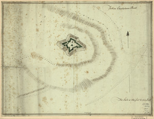
A Temporary project for a star redout [sic] to contain 150 men
![A Temporary project for a star redout [sic] to contain 150 men](https://bpldcassets.blob.core.windows.net/derivatives/images/commonwealth:z603vj703/image_access_800.jpg)
This map is also available in American Revolutionary Geographies Online (ARGO), a collections portal especially built for material relating to the American Revolutionary War Era. Visit ARGO to learn more about this item and explore the historical geography of North America in the late eighteenth century.
Item Information
- Title:
- A Temporary project for a star redout [sic] to contain 150 men
- Date:
-
[1778?]
- Format:
-
Maps/Atlases
Manuscripts
- Location:
- Library of Congress Geography and Map Division
- Collection (local):
-
Library of Congress Geography and Map Division
- Subjects:
-
Fortification--Massachusetts--Boston--Maps, Manuscript--Early works to 1800
Boston (Mass.)--Buildings, structures, etc--Maps, Manuscript--Early works to 1800
- Places:
-
Suffolk (county)Boston
- Extent:
- col. map on sheet 21 x 34 cm.
- Terms of Use:
-
No known copyright restrictions.
This work is licensed for use under a Creative Commons Attribution Non-Commercial Share Alike License (CC BY-NC-SA).

- Language:
-
English
- Catalog Record:
-
https://lccn.loc.gov/gm71000919
- Notes:
-
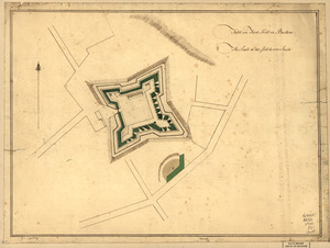
Manuscript, pen-and-ink and watercolor.
"No. 53."
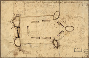
On verso, partly illegible and in a different hand: Boston ... part of the ... project for the war ...
Drawing of a fortification on the road to Roxbury near Boston Neck, with list of proposed guns.
Scale not given.
- LCCN:
-
gm 71000919