Nova, et integra universi orbis descriptio
Item Information
- Title:
- Nova, et integra universi orbis descriptio
- Title (alt.):
-
Nova, et integra vniversi orbis descriptio
- Description:
-
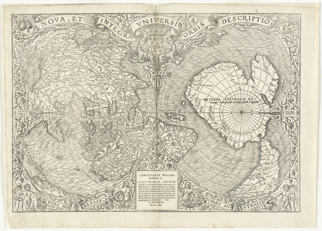
Fine, an eminent French cartographer, created this unique double cordiform or heart-shaped projection, emphasizing the northern and southern hemispheres. The European, Asian and African continents were prominently placed in the center of the left (northern) cordum. However, his treatment of the Americas was somewhat more tentative. By splitting the new World discoveries along the left edge of the northern cordum, it was not obvious that he had depicted these lands as a large peninsula attached to the Asian mainland. While this depiction contradicted Waldseemüller's model, Fine did retain the name America, which appears in the southern part of South America, in the right (southern) cordum. This portion of the map is dominated by a continent that was still speculative. Fine labeled it, "Terra Australis," based on Magellan's relatively recent passage through the strait at the southern tip of South America. Fine's use of a single cordiform projection in 1519, as well as this use of the double cordiform projection, introduced a tradition of similar world maps throughout the 16th century. While the projection has a mathematical basis, it presents a visually pleasing map. It is also conceivable, since the heart was a widespread Christian symbol, that the use of the heart-shaped projection added religious meaning to the contents of the map.
- Creator:
- Fine, Oronce, 1494-1555
- Contributor:
- Wechel, Chrestien, 1495-1554
- Date:
-
1540
- Format:
-
Maps/Atlases
- Location:
- Phillips Academy
- Collection (local):
-
Sidney R. Knafel Map Collection at Phillips Academy, Andover MA
- Subjects:
-
World maps--Early works to 1800
- Extent:
- 1 map ; 29 x 42 cm.
- Terms of Use:
-
Rights status not evaluated.
Contact host institution for more information.
- Publisher:
-
[Paris] :
Christianus Wechelus
- Scale:
-
Scale [ca. 1:80,000,000]
- Language:
-
Latin
- Notes:
-
Double cordiform map of the world.
Relief shown pictorially.
From Pomponius Mela's De orbis situ, Paris, 1540.
State 4.
- Notes (citation):
-
Shirley, R.W. Mapping the world, 66
Suarez, T. Shedding the veil, 19
- Identifier:
-
1330


