Wakefield, Massachusetts
Item Information
- Title:
- Wakefield, Massachusetts
- Creator:
- U.S. Coast and Geodetic Survey
- Name on Item:
-
United States Coast and Geodetic Survey
- Date:
-
1936
- Format:
-
Maps/Atlases
- Location:
- Lucius Beebe Memorial Library
- Collection (local):
-
Lucius Beebe Memorial Library Historic Maps
- Places:
-
Middlesex (county)Wakefield
- Extent:
- 1 map : b&w ; 26 x 24 cm.
- Terms of Use:
-
No known copyright restrictions.
No known restrictions on use.
- Publisher:
-
[Washington, D.C.] :
The Survey
- Scale:
-
Scale 1:26,400
- Language:
-
English
- Notes:
-
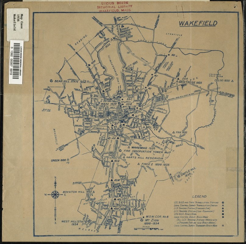
Map depicts entire town of Wakefield in 1936, showing streets, bodies of water, railroad lines, and U.S., state, and local triangulation stations, traverse stations, and benchmarks.
"Attached herewith is a compiled map showing the progress of the Local Control Survey within the limits of Wakefield, Massachusetts. The purpose of this organization is to provide, in every community, fixed points of horizontal control (geographic position) and vertical control (difference in elevation on a universal datum). On the map is indicated the general location of all stations established for horizontal control and all bench marks for vertical control. To designate points and the kind of control appropriate symbols are employed and explained in the 'Legend'. Information regarding each of the points can be obtained from this office upon application. The information available at horizontal control sites is (1) a description of the general location; (2) a diagram showing distances and directions to station reference points; (3) plane coordinates on the state system; (4) direction angles, distances and azimuths to adjacent stations; (5) elevation above mean sea level. Future public or private surveys may be tied to and developed upon the data available at all control stations. The positions of all important points, or of monuments, will be permanently established and recoverable at any future time. The Massachusetts Land Court has approved and adopted the statewide single system of plan coordinates which is a logical development of the original requirement of the court that all point locations shall be geographically defined. Vertical control has been established by the determination of elevations above mean sea level at the control stations in addition to the separate bench marks determined by level parties. These authoritative level benches will eliminate the necessity of using arbitrarily assumed elevations. Pending the ultimate publication in detail of the data established at any of the points indicated on the maps, the Local Control Survey will promptly respond to all requests for specific data, associated with the station. May we suggest that this letter and accompanying map be posted in a public bulletin board in your office or a public corridor leading thereto. This organization will receive suggestions for the location of additional control or requests for cooperation in any contemplated public improvement. - Mass. Geodetic Control Survey, sponsored by the Mass. Dept. of Public Works, William F. Callahan, Commissioner; George H. Delano, Chief Engineer; Elmer C. Houdlette, Director. " -- Text from typewritten letter dated February 20, 1936, affixed to back of map.
- Call #:
-
Local History Map Case Wakefield 1936
- Barcode:
-
31392003576919


