Nouus planiglobii terrestris per utrumque polum conspectus
Item Information
- Title:
- Nouus planiglobii terrestris per utrumque polum conspectus
- Title (alt.):
-
Novus planiglobii terrestris per utrumque polum conspectus
- Description:
-
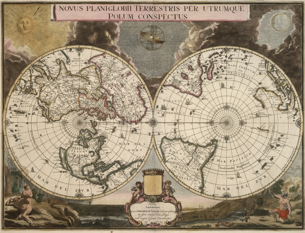
Another variation of the double hemisphere projection was one in which each of the spheres depicted the northern and southern hemispheres, rather than the eastern and western. An example of this polar-oriented projection is Gerard Valck's ornately decorated map first issued about 1695 and included in atlases published by Valck and Petrus Schenk during the early 1700s. Valck did not prepare this plate himself, but had purchased it from the stock of the former Dutch atlas publisher Joan Blaeu. The original plate was one of the last prepared for the Spanish edition of Blaeu's Atlas Major, which was never completed when the publishing house was destroyed by fire in 1672. The two spheres, which are adorned with ships and a symmetrical arrangement of compass roses along the Equator and the polar circles, are set against an artistic backdrop highlighting the Genesis story of creation. At the top is a dramatic presentation of the sun, moon, and stars emerging from clouds of darkness. The vignette at the bottom left reveals Adam and Eve's shame after leaving the Garden of Eden, while the vignette on the right may depict Adam in the Garden before the fall, as some scholars have suggested, or even Noah selecting pairs of animals for the ark. Since the geography of the polar regions was relatively unknown until the late-19th century, this projection was not commonly used. However, the use of polar-oriented projections was revitalized by Richard Edes Harrison in the mid-20th century as he prodded Americans to better appreciate their proximity to Europe and Asia during World War II.
- Creator:
- Valck, G. (Gerard), 1651 or 2-1726
- Name on Item:
-
penes Gerdardum Valck.
- Date:
-
[1695?]
- Format:
-
Maps/Atlases
- Location:
-
Boston Public Library
Norman B. Leventhal Map Center - Collection (local):
-
Norman B. Leventhal Map Center Collection
- Subjects:
-
World maps--Early works to 1800
- Places:
-
World
- Extent:
- 1 map : col. ; on sheet 54 x 65 cm.
- Terms of Use:
-
No known copyright restrictions.
No known restrictions on use.
- Publisher:
-
Amstelaedami :
Penes Gerardum Valck calcographum in foro vulgo den Dam sub signo Canis Excubantis
- Scale:
-
Scale not given.
- Language:
-
Latin
- Notes:
-
Relief shown pictorially.
Includes ill.
"Underneath Valck's imprint the erased signature of J. Blaeu can just be discerned, indicating that this plate was prepared in the last years of Joan Blaeu's life, in 1672-73"--Shirley, R.W. Mapping of the world, p. 477.
- Notes (exhibitions):
-
Exhibited in “Journeys of the Imagination,” at the Boston Public Library, Boston, MA, April - August 2006. MB (BRL)
Exhibited: "Unconventional Maps: Exploring the Stories of Cartographic Curiosities" organized by the Norman B. Leventhal Map Center at the Boston Public Library, 2011-2012.
Exhibited: "Literary Landscapes: Maps from Fiction" organized by the Norman B. Leventhal Map Center at the Boston Public Library, 2015.
- Identifier:
-
05_04_000186
- Call #:
-
G3200 1695 .V34
- Barcode:
-
39999052509831


