Novissima et accuratissima totius Americae descriptio
Item Information
- Title:
- Novissima et accuratissima totius Americae descriptio
- Description:
-
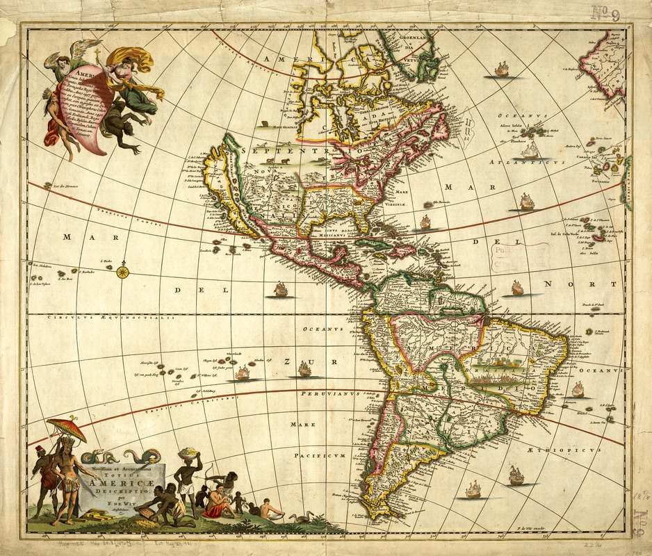
In comparison with DeWit's large wall map, this map purports to show the newest and most accurate information about the Americas. However, the geographic information presented here is not much different from the earlier map, especially in its perpetuation of the "California as an island" myth. All the source regions for Florida's recent immigration--Canada, Mexico, the West Indies, and northern South America--are included on both maps. While these regions have been depicted as separate geographic entities, there is an underlying reminder that they are extensions of European colonial powers: the southwestern tip of Europe (the Iberian peninsula) appears on the right edge of the map, not quite out of sight, while the use of certain place names reflects European relocation--Hispania Nova (Mexico and Central America), Nova Francia (Canada's St. Lawrence region), or Nova Britagna (Canada's Hudson Bay region). In addition, the map's iconography reinforces this interpretation, especially the upper left plaque, where an angel and a female figure bearing a cross symbolize the Christianizing of the native peoples, and in the lower left cartouche which shows natives bringing the wealth of the land (gold bars and baskets of grain) to an Indian chieftain, representing the European economic exploitation of the continent's mineral and agricultural wealth.
- Creator:
- Wit, Frederik de.
- Name on Item:
-
per F. De Wit.
- Date:
-
[1670?]
- Format:
-
Maps/Atlases
- Location:
-
Boston Public Library
Norman B. Leventhal Map Center - Collection (local):
-
Norman B. Leventhal Map Center Collection
- Subjects:
-
America--Maps--Early works to 1800
North America--Maps--Early works to 1800
South America--Maps--Early works to 1800
Central America--Maps--Early works to 1800
- Places:
-
North and Central America
South America
Mesoamerica (area)
North America (area)
South America
America
- Extent:
- 1 map : hand col. ; 54 x 63 cm.
- Terms of Use:
-
No known copyright restrictions.
No known restrictions on use.
- Publisher:
-
Amstelodami :
[s.n.]
- Scale:
-
Scale [ca. 1:35,000,000].
- Language:
-
Latin
- Notes:
-
Relief shown pictorially.
Includes ill.
California shown as an island with irregular coastline and islands on both sides.
Does not include the additional islands on lower left of map that were added in later editions.
Featured in the Faces & Places Exhibit, Kravis Center, Palm Beach, FL, since 2005. MB (BRL)
- Identifier:
-
05_04_000097
- Call #:
-
G3290 1670 .W5
- Barcode:
-
39999052507793


