Boston old and new
Item Information
- Title:
- Boston old and new
- Description:
-
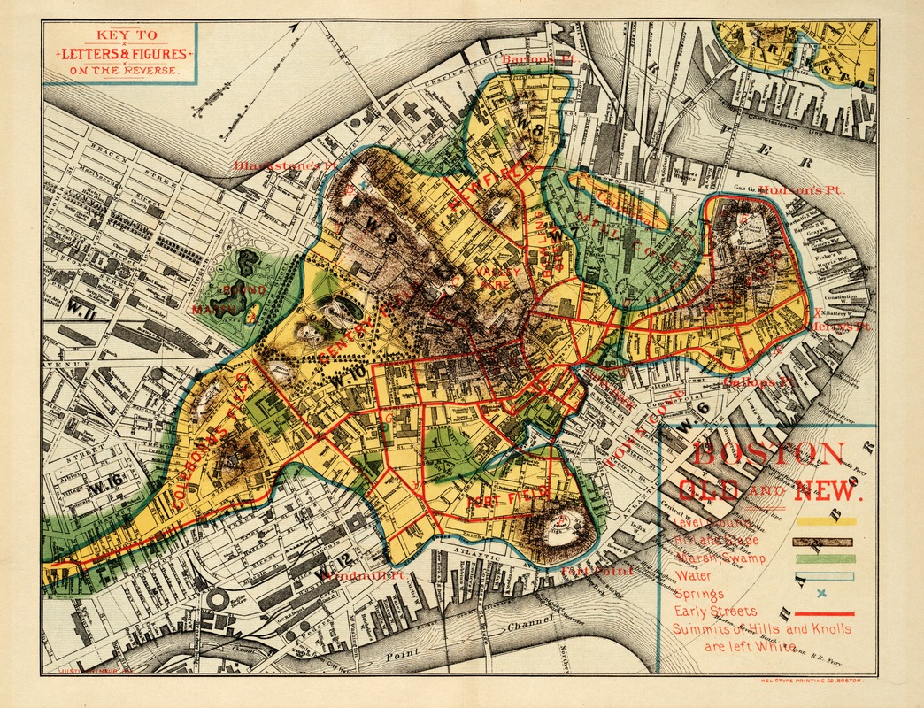
Noted historian and librarian, Justin Winsor created this unique map by superimposing the outline of the original Shawmut Peninsula onto an 1880 map of Boston. It was used as the frontispiece for the first volume of his "Memorial History of Boston, Including Suffolk County, Massachusetts", published in 1882. Though drawn without the assistance of computers or aerial photographs, it remains one of the most vivid diagrams of the radical transformation and enlargement of the Shawmut Peninsula during the 19th century.
- Creator:
- Winsor, Justin, 1831-1897
- Name on Item:
-
Justin Winsor, del.
- Date:
-
1880
- Format:
-
Maps/Atlases
- Location:
-
Boston Public Library
Norman B. Leventhal Map Center - Collection (local):
-
Norman B. Leventhal Map Center Collection
- Subjects:
-
Boston (Mass.)--History--Maps
- Places:
-
Suffolk (county)Boston
- Extent:
- 1 map : col. ; 28 x 37 cm.
- Terms of Use:
-
No known copyright restrictions.
No known restrictions on use.
- Publisher:
-
Boston :
Heliotype Print. Co.
- Scale:
-
Scale [ca. 1:11,700]
- Language:
-
English
- Notes:
-
Shows original shoreline and early place names and streets.
Relief shown by hachures.
Oriented with north toward the upper right.
Appears in Winsor's Memorial history of Boston, including Suffolk County, Massachusetts. Boston. 1882
On verso: index to early Boston points of interest.
- Notes (exhibitions):
-
Exhibited: "Faces & Places" organized by the Norman B. Leventhal Map Center at the Boston Public Library, 2003-2004.
- Identifier:
-
05_04_000083
- Call #:
-
G3764.B6S1 1880 .W5


