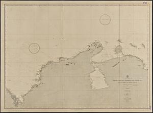
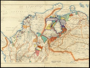
[Map of parts of Venezuela and Colombia]
![[Map of parts of Venezuela and Colombia]](https://bpldcassets.blob.core.windows.net/derivatives/images/commonwealth:4m90fm18q/image_access_800.jpg)
Item Information
- Title:
- [Map of parts of Venezuela and Colombia]
- Creator:
- Richard Mayer (Firm)
- Name on Item:
-
compiled published and copyright by Richard Mayer.
- Date:
-
[1910–1923]
- Format:
-
Maps/Atlases
- Location:
-
Boston Public Library
Norman B. Leventhal Map Center - Collection (local):
-
Norman B. Leventhal Map Center Collection
- Subjects:
-
Petroleum--Colombia--Maps
Petroleum--Venezuela--Maps
Venezuela--Maps
Colombia--Maps
- Places:
-
Venezuela
Colombia
- Extent:
- 1 map : color ; 70 x 110 cm + 1 sheet (46 x 26 cm) + 1 sheet (54 x 28 cm)
- Terms of Use:
-
Rights status not evaluated.
This work is licensed for use under a Creative Commons Attribution Non-Commercial No Derivatives License (CC BY-NC-ND).

- Publisher:
-
New York :
Richard Mayer,
- Scale:
-
Scale approximately 1:1,000,000
- Language:
-
English
- Notes:
-
Boston Public Library copy may be missing sheets or parts to the left and right of the map.
Relief shown by shading.
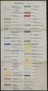
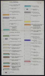
Accompanied by 2 sheets with key to land owned by oil companies.
- Notes (date):
-
This date is inferred.
- Identifier:
-
06_01_012001
- Call #:
-
G5280 1923 .R53
- Barcode:
-
39999065691139