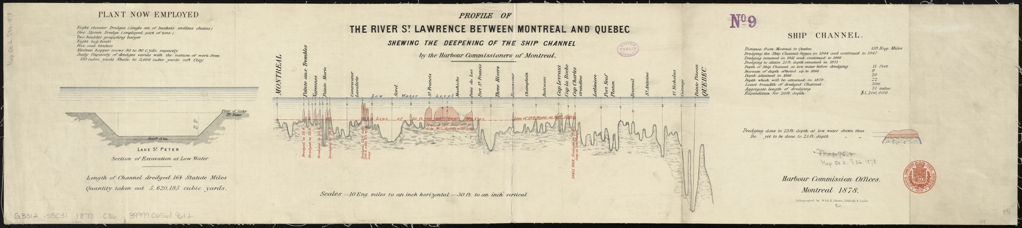
Profile of the river St. Lawrence between Montreal and Quebec shewing the deepening of the ship channel
Item Information
- Title:
- Profile of the river St. Lawrence between Montreal and Quebec shewing the deepening of the ship channel
- Creator:
- Harbour Commissioners of Montreal
- Name on Item:
-
by the Harbour Commissioers of Montreal.
- Date:
-
1878
- Format:
-
Maps/Atlases
- Location:
-
Boston Public Library
Norman B. Leventhal Map Center - Collection (local):
-
Norman B. Leventhal Map Center Collection
- Subjects:
-
Navigation--Saint Lawrence River
Hydrography--Saint Lawrence River--Maps
Saint Lawrence River--Maps
- Places:
-
Saint Lawrence River
- Extent:
- 1 profile : color ; sheet 21 x 97 cm
- Terms of Use:
-
No known copyright restrictions.
No known restrictions on use.
- Publisher:
-
Montreal :
Harbour Commission Offices,
- Scale:
-
Scale 1:633,600. 10 miles to an inch. Vertical scale 1:360. 30 feet to an inch
- Language:
-
English
- Notes:
-
Includes "plant now employed," section of Lake St. Peter and ship channel statistics.
- Identifier:
-
06_01_011752
- Call #:
-
G3312.S5C31 1878 .C36
- Barcode:
-
39999065689612


