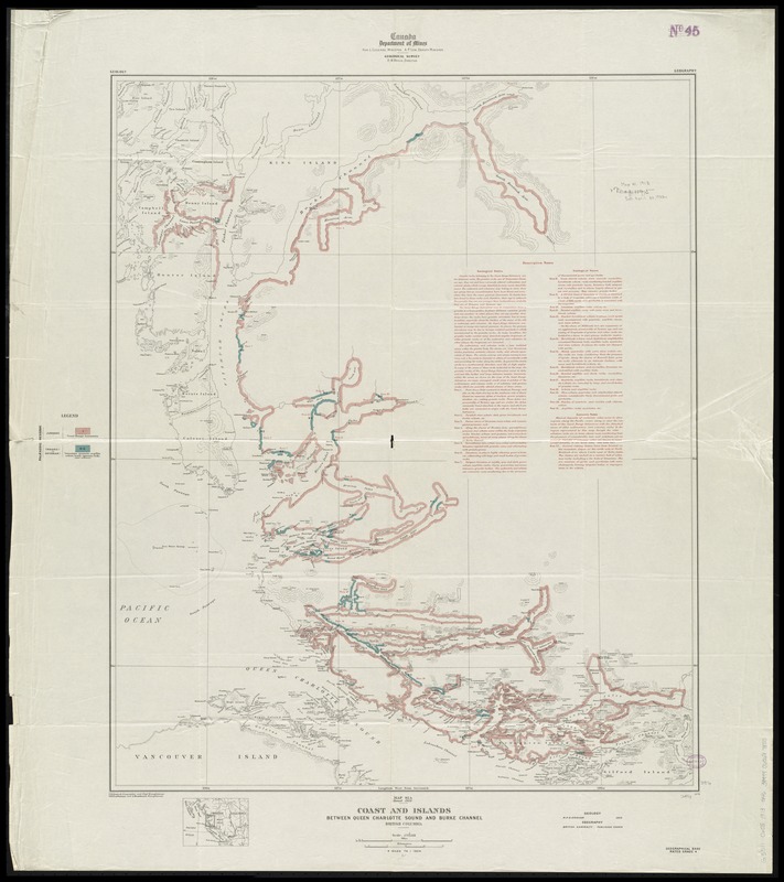
Coast and islands between Queen Charlotte Sound and Burke Channel, British Columbia
Item Information
- Title:
- Coast and islands between Queen Charlotte Sound and Burke Channel, British Columbia
- Creator:
- Geological Survey of Canada
- Publisher:
- Geological Survey of Canada
- Cartographer:
- Graham, R. P. D. (Richard Percival Devereux), 1880-1965
- Cartographer:
- Senécal, C. O. (Clovis Omer)
- Name on Item:
-
C.O. Senécal, geographer and chief draughtsman ; O.E. Prud'homme and A. Braidwood, draughtsmen ; geology R.P.D. Graham ; geography British Admiralty, published charts.
- Date:
-
1913
- Format:
-
Maps/Atlases
- Location:
-
Boston Public Library
Norman B. Leventhal Map Center - Collection (local):
-
Norman B. Leventhal Map Center Collection
- Subjects:
-
Geology--British Columbia--Maps
Coasts--British Columbia--Maps
Islands--British Columbia--Maps
British Columbia--Maps
- Places:
-
CanadaProvince of British Columbia (province)
- Extent:
- 1 map : color ; 75 x 61 cm
- Terms of Use:
-
No known copyright restrictions.
No known restrictions on use.
- Publisher:
-
Ottawa, Ontario :
Geological Survey of Canada,
- Scale:
-
Scale 1:253,440. 4 miles to 1 inch
- Language:
-
English
- Notes:
-
Relief shown by form lines and spot heights.
Includes location map and descriptive notes.
"Geographical base rated grade 4."
"1278."
- Identifier:
-
06_01_011600
- Call #:
-
G3511.C6C5 1913 .G46
- Barcode:
-
39999065687855