Map of Schuylkill County, Pennsylvania
Item Information
- Title:
- Map of Schuylkill County, Pennsylvania
- Description:
-
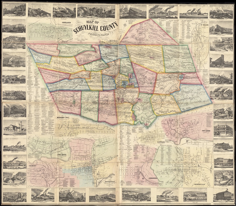
America Transformed: The economy of Schuylkill County, located in northeastern Pennsylvania, focused on anthracite coal mining during the 19th century. This county map documents how that activity dominated the landscape. Of the 37 marginal vignettes, 20 illustrate collieries – coal mines and connected buildings. An additional ten depict local iron manufacturers, fueled by the region’s coal. Also evident is the network of railroads and canals that shipped these resources to New York City and Philadelphia. The map identifies landowners’ names including many coal companies, and also displays street plans and directories for 23 towns, detailing retail activities and service industries within each.
- Creator:
- Scott, Walter, surveyor
- Name on Item:
-
from actual surveys by Walter Scott & W.J. Cox, surveyors ; coal lands drawn from the latest records and actual surveys by S. Lewis & J.S. Hawley Civil Engineers, Pottsville.
- Date:
-
1864
- Format:
-
Maps/Atlases
- Location:
-
Boston Public Library
Norman B. Leventhal Map Center - Collection (local):
-
Norman B. Leventhal Map Center Collection
- Subjects:
-
Real property--Pennsylvania--Schuylkill County--Maps
Landowners--Pennsylvania--Schuylkill County--Maps
Coal lands--Pennsylvania--Schuylkill County--Maps
Anthracite coal mines and mining--Pennsylvania--Schuylkill Sounty--Maps
Business enterprises--Pennsylvania--Schuylkill County--Directories
Schuylkill County (Pa.)--Maps
Ashland (Pa.)--Maps
Saint Clair (Schuylkill County, Pa.)--Maps
Port Carbon (Pa.)--Maps
Orwigsburg (Pa.)--Maps
Minersville (Pa.)--Maps
Cressona (Pa.)--Maps
Pottsville (Pa.)--Maps
Pine Grove (Schuylkill County, Pa.)--Maps
Tremont (Pa.)--Maps
Mahanoy City (Pa.)--Maps
- Places:
-
Schuylkill (county)Ashland
Schuylkill (county)Saint Clair
Schuylkill (county)Pottsville
Schuylkill (county)Port Carbon
Schuylkill (county)Orwigsburg
Schuylkill (county)Minersville
Schuylkill (county)Cressona
Schuylkill (county)Pine Grove
Schuylkill (county)Tremont
Schuylkill (county)Mahanoy City
- Extent:
- 1 map on 4 sheets : hand col. ; 114 x 126 cm.
- Terms of Use:
-
No known copyright restrictions.
No known restrictions on use.
- Publisher:
-
Philadelphia :
James D. Scott
- Scale:
-
Scale [1:59,400]. 300 perches to 1 in.
- Language:
-
English
- Notes:
-
Shows householders' names in rural areas, real-property tracts in mining townships, coal mining (anthracite) lands, and colliery locations; also shows lot lines, buildings, and owners' names in the borough insets.
Oriented with north to the upper right.
Relief shown by hachures.
Hand col. to distinguish townships and boroughs.
"Entered according to Act of Congress in the year [words not printed] Scott in ... and for the Eastern District [of] Pennsylvania."
Includes borough business directories and ill of collieries/industries/hotels.
Borough insets: Ashland -- Borough of St. Clair -- Port Carbon -- Orwigsburg -- Minersville -- Cressona -- Pottsville / surveyed by S. Lewis C.E. -- Pinegrove -- Tremont -- Mahanoy City.
BPL copy assembled, sectioned to 4 sheets and mounted on cloth.
- Notes (exhibitions):
-
Exhibited: "America transformed. Part 1: the United States expands westward," organized by the Norman B. Leventhal Map & Education Center at the Boston Public Library, 2019.
- Identifier:
-
06_01_011514
- Call #:
-
G3823.S3 1864 .S26
- Barcode:
-
39999065686980
- LCCN:
-
2012592180


