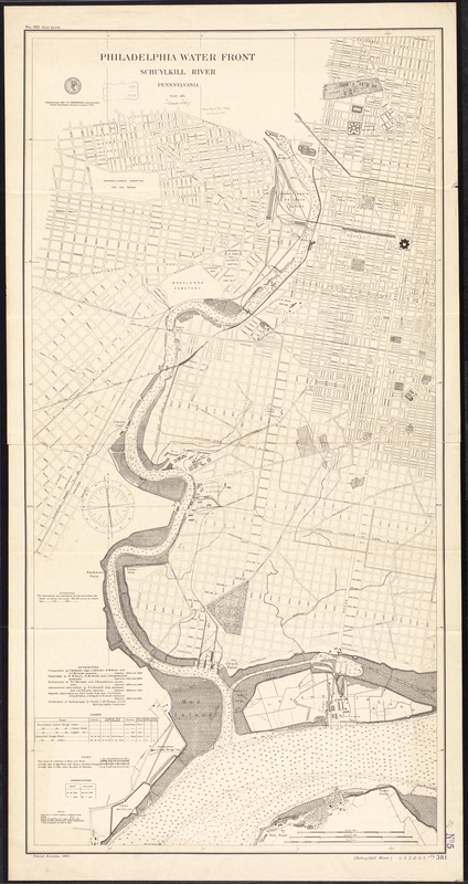
Philadelphia water front, Schuylkill River, Pennsylvania
Item Information
- Title:
- Philadelphia water front, Schuylkill River, Pennsylvania
- Title in lower margin :
- (Schuylkill River) U.S.C. & G.S. 381
- Creator:
- U.S. Coast and Geodetic Survey
- Name on Item:
-
published April 1891, T.C. Mendenhall, Superintendent ; verified B.A. Coloma, Assistant in charge of office ; U.S. Coast and Geodetic Survey.
- Date:
-
1892
- Format:
-
Maps/Atlases
- Location:
-
Boston Public Library
Norman B. Leventhal Map Center - Collection (local):
-
Norman B. Leventhal Map Center Collection
- Subjects:
-
Nautical charts--Pennsylvania--Philadelphia
Waterfronts--Pennsylvania--Philadelphia--Maps
Waterfronts--Pennsylvania--Schuylkill River--Maps
Schuylkill River (Pa.)--Maps
Philadelphia (Pa.)--Maps
- Places:
-
Berks (county)Schuylkill (river)
Philadelphia (county)Philadelphia
- Extent:
- 1 map ; 126 x 64 cm.
- Terms of Use:
-
No known copyright restrictions.
No known restrictions on use.
- Publisher:
-
[Washington, D.C.] :
U.S. Coast & Geodetic Survey
- Scale:
-
Scale 1:9,600
- Language:
-
English
- Notes:
-
Depths shown by soundings and bathymetric isolines.
Includes notes and tables.
"Printed November 1892."
- Identifier:
-
06_01_011493
- Call #:
-
G3824.P5P5 1892 .U82
- Barcode:
-
39999065685214