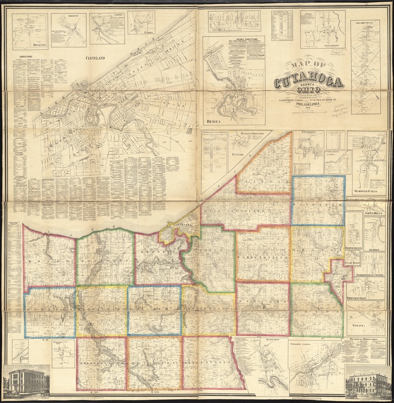
Map of Cuyahoga County, Ohio
Item Information
- Title:
- Map of Cuyahoga County, Ohio
- Creator:
- Hopkins, Griffith Morgan, Jr
- Name on Item:
-
from actual surveys and county records, under the supervision of G.M. Hopkins, Jr.
- Date:
-
1858
- Format:
-
Maps/Atlases
- Location:
-
Boston Public Library
Norman B. Leventhal Map Center - Collection (local):
-
Norman B. Leventhal Map Center Collection
- Subjects:
-
Geology--Ohio--Cuyahoga County--Maps
Landowners--Ohio--Cuyahoga County--Maps
Real property--Ohio--Cuyahoga County--Maps
Cuyahoga County (Ohio)--Maps
- Places:
-
Cuyahoga (county)
- Extent:
- 1 map on 4 sheets : color ; 135 x 132 cm
- Terms of Use:
-
No known copyright restrictions.
No known restrictions on use.
- Publisher:
-
Philadelphia :
S.H. Matthews
- Scale:
-
Scale 1:42,240. 1 1/2 inches per mile
- Language:
-
English
- Notes:
-
Relief shown by hachures and spot heights.
Insets: Royalton -- Brighton -- Newburg -- Parma -- Cleveland -- Euclid St. in east Cleveland -- Berea -- Doans Corners -- Collamer Village -- Euclid -- Brooklyn -- Outline geology -- Olmstead Falls -- Gates Mills -- Independence -- Albion -- Euclid Depot -- Warrensville Center -- Brecksville -- Solon -- Chagrin Falls -- Bedford -- Strongsville -- Westview of Olmsted Station.
Includes business directories, geological section or profile, total taxable property table, 24 insets and 2 views of public properties.
BPL copy assembled, sectioned into 4 pieces and mounted on cloth.
- Identifier:
-
06_01_011304
- Call #:
-
G4083.C9 1858 .H67
- Barcode:
-
39999065683243
- LCCN:
-
2012591128


