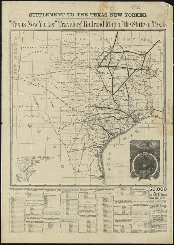
Texas New Yorker travelers' railroad map of the State of Texas
Item Information
- Title:
- Texas New Yorker travelers' railroad map of the State of Texas
- Title (alt.):
-
Travelers' railroad map of the State of Texas
Railroad map of the State of Texas
- Creator:
- George H. Sweet & Co
- Date:
-
[1870]
- Format:
-
Maps/Atlases
- Location:
-
Boston Public Library
Norman B. Leventhal Map Center - Collection (local):
-
Norman B. Leventhal Map Center Collection
- Subjects:
-
Railroads--Texas--Maps
Texas--Maps
- Places:
-
Texas
- Extent:
- 1 map ; 51 x 51 cm., on sheet 81 x 57 cm.
- Terms of Use:
-
No known copyright restrictions.
No known restrictions on use.
- Publisher:
-
New York :
George H. Sweet & Co.
- Scale:
-
Scale [ca. 1:2,000,000]
- Language:
-
English
- Notes:
-
Shows railroads, counties, and county seats in south, central, and east Texas.
Includes ill. and statistics.
Inset: [location map].
At head of title: "Supplement to the Texas New Yorker."
Prime meridians: Washington and Greenwich.
Text and statistics on verso, p. 227, 228, 230, 231.
Mounted on cloth. Verso covered by cloth.
Date from text on verso. Counties established in 1870 not shown.
- Notes (date):
-
This date is inferred.
- Identifier:
-
06_01_011086
- Call #:
-
G4031.P3 1870 .G46
- Barcode:
-
39999065681544