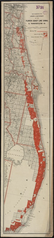
Map showing the lands & waterway of the Florida Coast Line Canal & Transportation Co
Item Information
- Title:
- Map showing the lands & waterway of the Florida Coast Line Canal & Transportation Co
- Date:
-
[1890?–1899?]
- Format:
-
Maps/Atlases
- Location:
-
Boston Public Library
Norman B. Leventhal Map Center - Collection (local):
-
Norman B. Leventhal Map Center Collection
- Subjects:
-
Real property--Florida--Maps
Coasts--Florida--Maps
Florida--Maps
Atlantic Coast (Fla.)--Maps
- Places:
-
Florida
- Extent:
- 1 map : col. ; 93 x 18 cm.
- Terms of Use:
-
No known copyright restrictions.
No known restrictions on use.
- Publisher:
-
Florida :
Florida Coast Line Canal & Transportation Co.
- Scale:
-
Scale [1:633,600]
- Language:
-
English
- Notes:
-
Shows waterways, county boundaries, and land survey parcels.
Oriented with north towards the upper right.
"5677 E."
- Identifier:
-
06_01_010953
- Call #:
-
G3932.C6G46 1890 .M37
- Barcode:
-
39999065679159