The state of New Jersey : economic geology
Item Information
- Title:
- The state of New Jersey : economic geology
- Title (alt.):
-
Economic geology
- Creator:
- Geological Survey of New Jersey
- Name on Item:
-
Geological Survey of New Jersey.
- Date:
-
1880
- Format:
-
Maps/Atlases
- Location:
-
Boston Public Library
Norman B. Leventhal Map Center - Collection (local):
-
Norman B. Leventhal Map Center Collection
- Subjects:
-
Geology--New Jersey--Maps
Soils--New Jersey--Maps
Iron mines and mining--New Jersey--Maps
New Jersey--Maps
- Places:
-
New Jersey
- Extent:
- 1 map : col. ; 78 x 42 cm.
- Terms of Use:
-
No known copyright restrictions.
No known restrictions on use.
- Publisher:
-
[Trenton, N.J.] :
The Survey
- Scale:
-
Scale [1:380,160]. 6 miles to 1 inch
- Language:
-
English
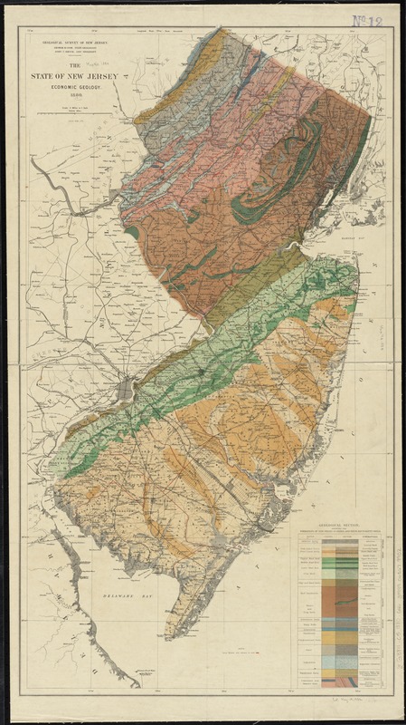
- Notes:
-
Iron mines are shown in red.
"George H. Cook, State Geologist."
Includes "Geological section showing the formations of New Jersey in order, and their equivalent soils."
From: Annual report of the state geologist for the year 1879.
- Identifier:
-
06_01_010880
- Call #:
-
G3811.C5 1880 .G46
- Barcode:
-
39999065679902


