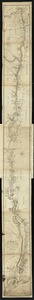
[Willard's new map of the Hudson River for 1844]
![[Willard's new map of the Hudson River for 1844]](https://bpldcassets.blob.core.windows.net/derivatives/images/commonwealth:b8516310f/image_access_800.jpg)
Item Information
- Title:
- [Willard's new map of the Hudson River for 1844]
- Title (alt.):
-
Hudson River
New map of the Hudson River
- Creator:
- Willard, Henry A.
- Date:
-
[1844]
- Format:
-
Maps/Atlases
- Location:
-
Boston Public Library
Norman B. Leventhal Map Center - Collection (local):
-
Norman B. Leventhal Map Center Collection
- Subjects:
-
Hudson River (N.Y. and N.J.)--Maps
Hudson River Valley (N.Y. and N.J.)--Maps
- Places:
-
Hudson River
New York
- Extent:
- 1 map ; 7 x 63 cm.
- Terms of Use:
-
No known copyright restrictions.
No known restrictions on use.
- Publisher:
-
[Troy, N.Y.?] :
Henry A. Willard
- Scale:
-
Scale [ca. 1:600,000]
- Language:
-
English
- Notes:
-
Relief shown by hachures.
Oriented with north to the right.
Includes "Rail-road from Troy to Schenectady" and "Rail-road from Troy to Greenbush."
Map from Willard's new map of the Hudson River and rail-road guide for 1844.
- Notes (date):
-
This date is inferred.
- Identifier:
-
06_01_010662
- Call #:
-
G3802.H9 1844 .W55
- Barcode:
-
39999065675116