Map of the counties of Chenango and Cortland, New York : from actual surveys
Item Information
- Title:
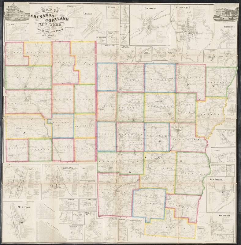
- Map of the counties of Chenango and Cortland, New York : from actual surveys
- Creator:
- Warner, A.
- Name on Item:
-
by A. & C.S. Warner, S.N. & F.W. Beers & B. Nichols ; Worley & Bracher, engravers.
- Date:
-
1863–1863
- Format:
-
Maps/Atlases
- Location:
-
Boston Public Library
Norman B. Leventhal Map Center - Collection (local):
-
Norman B. Leventhal Map Center Collection
- Subjects:
-
Landowners--New York (State)--Chenango County--Maps
Landowners--New York (State)--Cortland County--Maps
Real property--New York (State)--Chenango County--Maps
Real property--New York (State)--Cortland County--Maps
Chenango County (N.Y.)--Maps
Cortland County (N.Y.)--Maps
- Places:
-
Cortland (county)
Chenango (county)
- Extent:
- 1 map : hand color ; 160 x 158 cm
- Terms of Use:
-
No known copyright restrictions.
No known restrictions on use.
- Publisher:
-
Philadelphia ; Philadelphia :
Published by A. Pomeroy & S.W. Treat, ; F. Bourquin & Co., Printr.,
- Scale:
-
Scale 1:50,688. 1 1/4 in. to the mile
- Language:
-
English
- Notes:
-
Relief shown by hachures.
Shows landowners.
Includes distance charts, business directories, and illustrations.
Ancillary maps: Afton -- Bainbridge -- Bennettsville -- Chenango Forks -- Cincinnatus -- Columbus -- Cortland -- Coventry -- Cuyler -- Earlville -- East Greene -- East Pharsalia -- Freetown Corners -- Greene -- Guilford Po -- Harford -- Holmesville -- Homer -- Lower Cincinnatus -- Marathon McDonough -- McGrawville -- Mount Upton -- New Berlin -- North Norwich -- Norwich -- Otselic -- Oxford -- Pitcher -- Preble -- Preston -- Scott -- Sherburne -- Sherburne Quarters -- Smithville Flats -- Smyrna -- South Harford -- South Otselic-- Texas Valley -- Truxton -- Union Valley -- Virgil -- Willett.
- Identifier:
-
06_01_010636
- Call #:
-
G3803.C6 1863 .W37
- Barcode:
-
39999065676841
- LCCN:
-
2012593651


