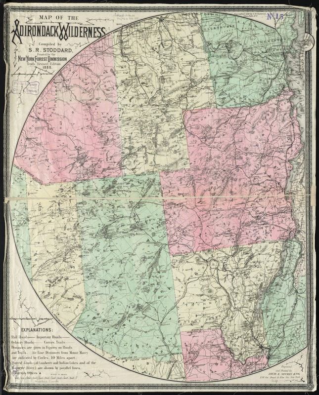
Map of the Adirondack wilderness
Item Information
- Title:
- Map of the Adirondack wilderness
- Creator:
- Stoddard, Seneca Ray, 1844-1917
- Name on Item:
-
compiled by S.R. Stoddard.
- Date:
-
1888
- Format:
-
Maps/Atlases
- Location:
-
Boston Public Library
Norman B. Leventhal Map Center - Collection (local):
-
Norman B. Leventhal Map Center Collection
- Subjects:
-
Adirondack Mountains (N.Y.)--Maps
- Places:
-
New YorkAdirondack Mountains
- Extent:
- 1 map : col. ; 79 x 64 cm.
- Terms of Use:
-
No known copyright restrictions.
No known restrictions on use.
- Publisher:
-
Glens Falls, N.Y :
S.R. Stoddard
- Edition:
- 10th rev. ed.
- Scale:
-
Scale [ca. 1:253,440]
- Language:
-
English
- Notes:
-
Shows natural features, railroads, important roads, ordinary roads, carries and trails. "Distances are given in figures on roads and trails. Air-line distances from Mount Marcy are indicated by circles, 10 miles apart."
Relief shown by hachures and spot heights.
Prime meridians: Greenwich and Washington. Latitudes not indicated.
Neat line on the north, west, and south is a circle whose diameter is ca. 120 mi. on the 74th meridian W of Greenwich (also nominally 3° E of Washington); center just west of Mount Marcy.
"Printed for the New York Forest Commission."
- Identifier:
-
06_01_010619
- Call #:
-
G3802.A2 1888 .S76
- Barcode:
-
39999065675249