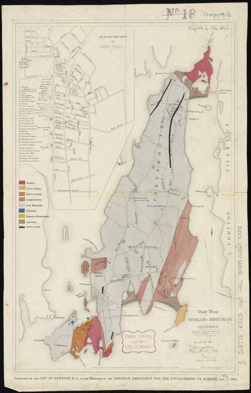
Road map of the island of Rhode Island, or Aquidneck
Item Information
- Title:
- Road map of the island of Rhode Island, or Aquidneck
- Creator:
- Hammett, Charles E. (Charles Edward), 1832-1902
- Name on Item:
-
surveyed November, 1849 by Chas. E. Hammett Jr. ; drawn by Geo F. Turner.
- Date:
-
1860
- Format:
-
Maps/Atlases
- Location:
-
Boston Public Library
Norman B. Leventhal Map Center - Collection (local):
-
Norman B. Leventhal Map Center Collection
- Subjects:
-
Roads--Rhode Island--Rhode Island (Island)--Maps
Rhode Island (R.I. : Island)--Maps
- Places:
-
Newport (county)Rhode Island (island)
- Extent:
- 1 map : col. ; 39 x 25 cm.
- Terms of Use:
-
No known copyright restrictions.
No known restrictions on use.
- Publisher:
-
Newport, R.I.? :
[City of Newport, R.I.]
- Scale:
-
Scale [ca. 1:60,000]
- Language:
-
English
- Notes:
-
Shows geology.
Relief shown by hachures.
Inset: Plan of the town of Newport.
"Presented by the City of Newport, R.I., to the members of the American Association for the Advancement of Science, Aug. 1, 1860."
- Identifier:
-
06_01_010567
- Call #:
-
G3772.R5C5 1860 .H36
- Barcode:
-
39999065675835