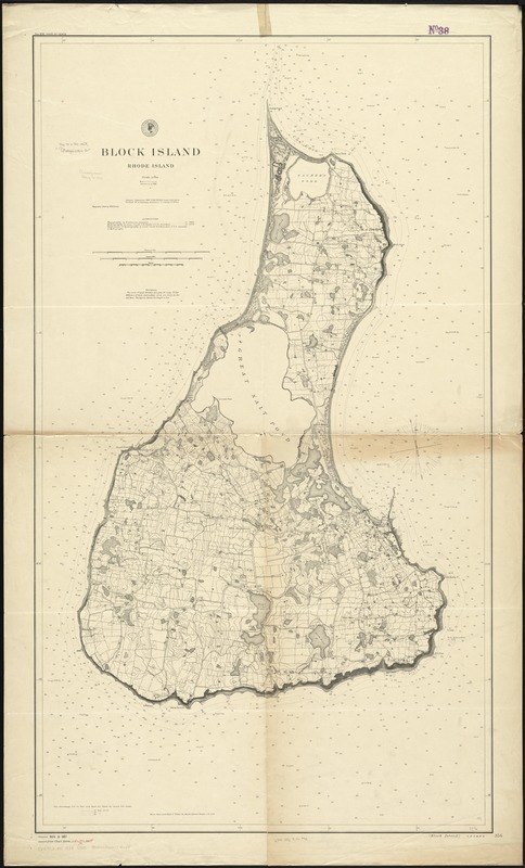
Block Island, Rhode Island
Item Information
- Title:
- Block Island, Rhode Island
- Title in lower right margin :
- Block Island
- Creator:
- U.S. Coast and Geodetic Survey
- Name on Item:
-
issued September 1887, F.M. Thorn, superintendent ; verified, B.A. Colonna ; topography inked by W.H. Dennis ; authorities: topography by W.H. Dennis in 1886 ; hydrography by C.M. Chester in 1878 ; verification of hydrography by W.H. Brownson.
- Date:
-
1888
- Format:
-
Maps/Atlases
- Location:
-
Boston Public Library
Norman B. Leventhal Map Center - Collection (local):
-
Norman B. Leventhal Map Center Collection
- Subjects:
-
Nautical charts--Rhode Island--Block Island (Island)
Block Island (R.I. : Island)--Maps
- Places:
-
Washington (county)Block Island (island)
- Extent:
- 1 map ; 125 x 71 cm.
- Terms of Use:
-
No known copyright restrictions.
No known restrictions on use.
- Publisher:
-
[Washington, D.C.] :
United States Coast and Geodetic Survey
- Edition:
- Aids to navigation corr. to 1888.
- Scale:
-
Scale 1:10,000
- Language:
-
English
- Notes:
-
Relief shown by contours, spot heights, and landform drawings. Depths shown by soundings and isolines.
"No. 356"--Upper left margin.
- Identifier:
-
06_01_010559
- Call #:
-
G3772.B5 1888 .U55
- Barcode:
-
39999065674044