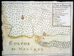
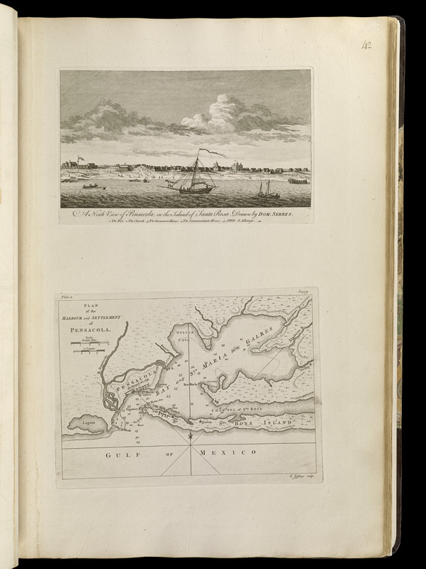
North view of Pensacola, on the island of Santa Rosa ; Plan of the harbour and settlement of Pensacola
This map is also available in American Revolutionary Geographies Online (ARGO), a collections portal especially built for material relating to the American Revolutionary War Era. Visit ARGO to learn more about this item and explore the historical geography of North America in the late eighteenth century.
Item Information
- Title:
- North view of Pensacola, on the island of Santa Rosa ; Plan of the harbour and settlement of Pensacola
- Title (alt.):
-
North view of Pensacola, on the island of Santa Rosa / drawn by Dom. Serres
- Creator:
- Jefferys, Thomas, -1771
- Publisher:
- Sayer, Robert, 1725-1794
- Name on Item:
-
T. Jefferys sculp.
- Date:
-
[1768]
- Format:
-
Maps/Atlases
- Location:
-
Boston Public Library
Norman B. Leventhal Map Center - Collection (local):
-
Norman B. Leventhal Map Center Collection
- Subjects:
-
Nautical charts--Florida--Pensacola--Early works to 1800
Pensacola (Fla.)--Maps--Early works to 1800
Pensacola (Fla.)--Aerial views--Early works to 1800
- Places:
-
Escambia (county)Pensacola
- Extent:
- 1 view and 1 map on 1 sheet ; 16 x 27 cm. and 19 x 26 cm., on sheet 56 x 37 cm.
- Terms of Use:
-
No known copyright restrictions.
No known restrictions on use.
- Publisher:
-
London :
Printed for Robert Sayer, ... and Thomas Jefferys
- Scale:
-
Scale [ca. 1:168,000]
- Language:
-
English
- Notes:
-
Depths shown by soundings.
Above neatline of map: Plate 2 (left) -- page 9 (right).
View includes references.
Appears in Jefferys' General topography of North America and the West Indies. London: Printed for Robert Sayer, ... and Thomas Jefferys, 1768.
- Notes (date):
-
This date is inferred.
- Notes (citation):
-
LC Maps of North America, 1658
Cresswell, D. American Revolution in drawings and prints, 613
Phillips. List of maps of America, p. 690
Phillips, 1196
- Identifier:
-
4000137_0080
- Call #:
-
G1105 .J4 1768
- Barcode:
-
30000003255929