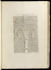
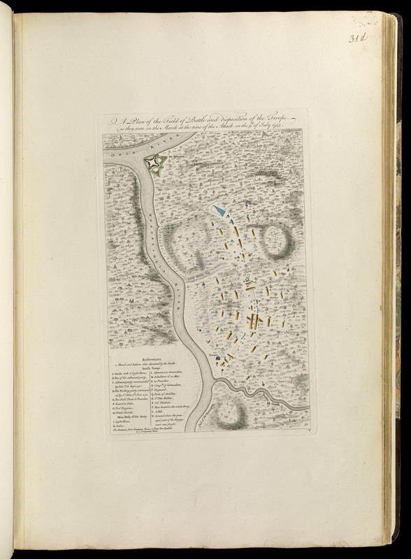
A plan of the field of battle and disposition of the troops, as they were on the march at the time of the attack on the 9th of July, 1755
This map is also available in American Revolutionary Geographies Online (ARGO), a collections portal especially built for material relating to the American Revolutionary War Era. Visit ARGO to learn more about this item and explore the historical geography of North America in the late eighteenth century.
Item Information
- Title:
- A plan of the field of battle and disposition of the troops, as they were on the march at the time of the attack on the 9th of July, 1755
- Creator:
- Orme, Robert, -1781
- Date:
-
[1768]
- Format:
-
Maps/Atlases
- Location:
-
Boston Public Library
Norman B. Leventhal Map Center - Collection (local):
-
Norman B. Leventhal Map Center Collection
- Subjects:
-
Tactics--Maps--Early works to 1800
Braddock's Campaign, 1755--Maps--Early works to 1800
United States--History--French and Indian War, 1754-1763--Maps--Early works to 1800
Fort Duquesne (Pa.)--Maps--Early works to 1800
- Places:
-
Allegheny (county)Pittsburgh
- Extent:
- 1 map : hand col. ; 32 x 21 cm.
- Terms of Use:
-
No known copyright restrictions.
No known restrictions on use.
- Publisher:
-
London :
Printed for Robert Sayer, ... and Thomas Jefferys
- Scale:
-
Scale [ca. 1:52,000]
- Language:
-
English
- Notes:
-
Shows the arrangement of troops in Braddock's attack on Fort Duquesne.
Oriented with north towards the bottom.
Relief shown by hachures.
Includes references.
In lower right: V.
Appears in Jefferys' General topography of North America and the West Indies. London: Printed for Robert Sayer, ... and Thomas Jefferys, 1768.
- Notes (date):
-
This date is inferred.
- Identifier:
-
4000137_0062
- Call #:
-
G1105 .J4 1768
- Barcode:
-
30000003254675